
Make a donation
Gear up for your next adventure:
As an Amazon Associate, this site earns from qualifying purchases at no extra cost to you.
Weißbach topographic map
Click on the map to display elevation.
Make a donation
Gear up for your next adventure:
As an Amazon Associate, this site earns from qualifying purchases at no extra cost to you.
Weißbach
Weißbach liegt im unteren Kochertal an der Mündung des Langenbachs in den Kocher zwischen 200 und 430 m ü. NN Höhe, 10 km westlich der Kreisstadt Künzelsau. Die Gemeinde besteht aus den ehemals selbständigen Ortschaften Weißbach mit dem Weiler Guthof und Crispenhofen mit dem Weiler Halberg.
Make a donation
Gear up for your next adventure:
As an Amazon Associate, this site earns from qualifying purchases at no extra cost to you.
About this map
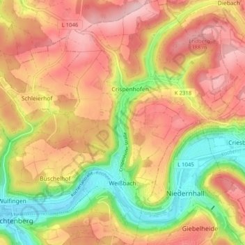
Name: Weißbach topographic map, elevation, terrain.
Average elevation: 1,027 ft
Minimum elevation: 636 ft
Maximum elevation: 1,339 ft
Make a donation
Gear up for your next adventure:
As an Amazon Associate, this site earns from qualifying purchases at no extra cost to you.
Other topographic maps
Click on a map to view its topography, its elevation and its terrain.
Waldzimmern
Deutschland > Baden-Württemberg > Hohenlohekreis > Niedernhall
Average elevation: 1,155 ft
Make a donation
Gear up for your next adventure:
As an Amazon Associate, this site earns from qualifying purchases at no extra cost to you.
Hohebach
Deutschland > Baden-Württemberg > Hohenlohekreis
Erstmals urkundlich erwähnt wird Hohebach 1238, als Pfarrer Conrad von Hohebach dem Konrad von Krautheim Güter abkauft, um sie der Kirche zum Unterhalt eines ewigen Lichtes zu schenken. Ursprünglich war Hohebach im Besitz der Herren von Krautheim, die Herren von Hohebach saßen als ihre Dienstleute auf dem…
Average elevation: 1,132 ft
Buchhorn
Deutschland > Baden-Württemberg > Hohenlohekreis > Heuberg > Buchhorn
Average elevation: 1,076 ft
Öhringen
Deutschland > Baden-Württemberg > Hohenlohekreis > Öhringen > Öhringen
Öhringen liegt im westlichen, tiefer gelegenen Teil der Hohenloher Ebene, zwischen der Keuperstufe der Schwäbisch-Fränkischen Waldberge und dem Kochertal. Die Stadt breitet sich über das flache Tal der Ohrn aus, eines kleinen Flusses, der etwa 10 km talwärts im Stadtteil Ohrnberg in den Kocher mündet.…
Average elevation: 883 ft
Make a donation
Gear up for your next adventure:
As an Amazon Associate, this site earns from qualifying purchases at no extra cost to you.
Tiefensall
Deutschland > Baden-Württemberg > Hohenlohekreis > Friedrichsruhe
Average elevation: 1,010 ft
Make a donation
Gear up for your next adventure:
As an Amazon Associate, this site earns from qualifying purchases at no extra cost to you.
Obersteinbach
Deutschland > Baden-Württemberg > Hohenlohekreis > Waldenburg
Average elevation: 1,460 ft
Make a donation
Gear up for your next adventure:
As an Amazon Associate, this site earns from qualifying purchases at no extra cost to you.
Hohe Straße
Deutschland > Baden-Württemberg > Hohenlohekreis > Schöntal > Westernhausen
Average elevation: 1,066 ft
Make a donation
Gear up for your next adventure:
As an Amazon Associate, this site earns from qualifying purchases at no extra cost to you.
Domäne Hohebuch
Deutschland > Baden-Württemberg > Hohenlohekreis > Waldenburg
Average elevation: 1,171 ft
Make a donation
Gear up for your next adventure:
As an Amazon Associate, this site earns from qualifying purchases at no extra cost to you.
Hofratsmühle
Deutschland > Baden-Württemberg > Hohenlohekreis > Künzelsau > Garnberg
Average elevation: 1,132 ft
Make a donation
Gear up for your next adventure:
As an Amazon Associate, this site earns from qualifying purchases at no extra cost to you.
Neufelser Mühle
Deutschland > Baden-Württemberg > Hohenlohekreis > Neuenstein
Average elevation: 1,096 ft
Unterhof
Deutschland > Baden-Württemberg > Hohenlohekreis > Künzelsau > Gaisbach
Average elevation: 1,188 ft
Gewerbepark Hohenlohe
Deutschland > Baden-Württemberg > Hohenlohekreis > Waldenburg
Average elevation: 1,178 ft
Make a donation
Gear up for your next adventure:
As an Amazon Associate, this site earns from qualifying purchases at no extra cost to you.
Make a donation
Gear up for your next adventure:
As an Amazon Associate, this site earns from qualifying purchases at no extra cost to you.
Obersöllbach
Deutschland > Baden-Württemberg > Hohenlohekreis > Neuenstein > Obersöllbach
Average elevation: 988 ft
Make a donation
Gear up for your next adventure:
As an Amazon Associate, this site earns from qualifying purchases at no extra cost to you.
Löhleinsberg
Deutschland > Baden-Württemberg > Hohenlohekreis > Hollenbach > Löhleinsberg
Average elevation: 1,237 ft
Eichelshof
Deutschland > Baden-Württemberg > Hohenlohekreis > Schöntal > Eichelshof
Average elevation: 1,007 ft
Make a donation
Gear up for your next adventure:
As an Amazon Associate, this site earns from qualifying purchases at no extra cost to you.
Make a donation
Gear up for your next adventure:
As an Amazon Associate, this site earns from qualifying purchases at no extra cost to you.
Make a donation
Gear up for your next adventure:
As an Amazon Associate, this site earns from qualifying purchases at no extra cost to you.