
Make a donation
Gear up for your next adventure:
As an Amazon Associate, this site earns from qualifying purchases at no extra cost to you.
Berkeley Township topographic map
Click on the map to display elevation.
Make a donation
Gear up for your next adventure:
As an Amazon Associate, this site earns from qualifying purchases at no extra cost to you.
About this map
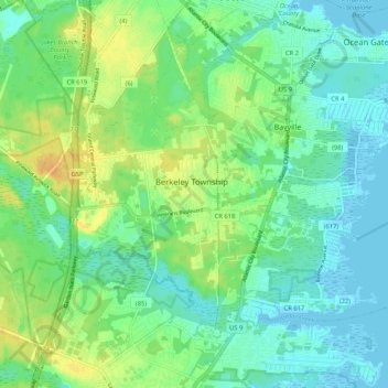
Name: Berkeley Township topographic map, elevation, terrain.
Average elevation: 33 ft
Minimum elevation: -10 ft
Maximum elevation: 89 ft
Ocean County trails, hiking, mountain biking, running and outdoor activities
Make a donation
Gear up for your next adventure:
As an Amazon Associate, this site earns from qualifying purchases at no extra cost to you.
Other topographic maps
Click on a map to view its topography, its elevation and its terrain.
Holiday Heights
United States > New Jersey > Ocean County > Berkeley Township
Average elevation: 52 ft
Cedar Glen Lakes
United States > New Jersey > Ocean County > Manchester Township > Cedar Glen Lakes
Average elevation: 154 ft
Cedar Glen West
United States > New Jersey > Ocean County > Manchester Township > Cedar Glen West
Average elevation: 79 ft
Make a donation
Gear up for your next adventure:
As an Amazon Associate, this site earns from qualifying purchases at no extra cost to you.
Jacques Cousteau National Estuarine Research Reserve
United States > New Jersey > Ocean County
Average elevation: 16 ft
Make a donation
Gear up for your next adventure:
As an Amazon Associate, this site earns from qualifying purchases at no extra cost to you.
Island Beach State Park
United States > New Jersey > Ocean County > Berkeley Township
Average elevation: 3 ft
Make a donation
Gear up for your next adventure:
As an Amazon Associate, this site earns from qualifying purchases at no extra cost to you.
Little Egg Harbor
United States > New Jersey > Ocean County > Little Egg Harbor Township
Average elevation: 7 ft
Make a donation
Gear up for your next adventure:
As an Amazon Associate, this site earns from qualifying purchases at no extra cost to you.