
Jacques Cousteau National Estuarine Research Reserve topographic map
Interactive map
Click on the map to display elevation.
About this map
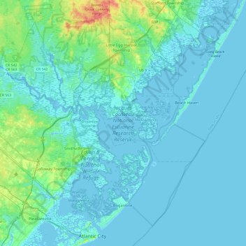
Name: Jacques Cousteau National Estuarine Research Reserve topographic map, elevation, terrain.
Average elevation: 16 ft
Minimum elevation: -13 ft
Maximum elevation: 151 ft
Ocean County trails, hiking, mountain biking, running and outdoor activities
Other topographic maps
Click on a map to view its topography, its elevation and its terrain.
Mystic Islands
United States > New Jersey > Ocean County > Little Egg Harbor Township
Average elevation: 3 ft
Cranberry Hill
United States > New Jersey > Ocean County > Lacey Township > Forked River
Average elevation: 33 ft
Saint Vladimirs
United States > New Jersey > Ocean County > Jackson Township
Average elevation: 138 ft
Keswick Grove
United States > New Jersey > Ocean County > Manchester Township
Average elevation: 115 ft
Mantoloking Estates
United States > New Jersey > Ocean County > Brick Township
Average elevation: 0 ft
West Tuckerton Landing
United States > New Jersey > Ocean County > Tuckerton > West Tuckerton Landing
Average elevation: 16 ft