
Make a donation
Gear up for your next adventure:
As an Amazon Associate, this site earns from qualifying purchases at no extra cost to you.
Plumsted Township topographic map
Click on the map to display elevation.
Make a donation
Gear up for your next adventure:
As an Amazon Associate, this site earns from qualifying purchases at no extra cost to you.
About this map
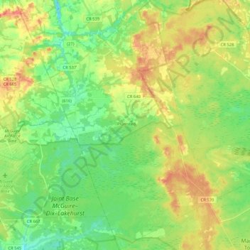
Name: Plumsted Township topographic map, elevation, terrain.
Average elevation: 121 ft
Minimum elevation: 46 ft
Maximum elevation: 226 ft
Ocean County trails, hiking, mountain biking, running and outdoor activities
Make a donation
Gear up for your next adventure:
As an Amazon Associate, this site earns from qualifying purchases at no extra cost to you.
Other topographic maps
Click on a map to view its topography, its elevation and its terrain.
Cranberry Hill
United States > New Jersey > Ocean County > Lacey Township > Forked River
Average elevation: 33 ft
Make a donation
Gear up for your next adventure:
As an Amazon Associate, this site earns from qualifying purchases at no extra cost to you.
Keswick Grove
United States > New Jersey > Ocean County > Manchester Township
Average elevation: 115 ft
Make a donation
Gear up for your next adventure:
As an Amazon Associate, this site earns from qualifying purchases at no extra cost to you.
Saint Vladimirs
United States > New Jersey > Ocean County > Jackson Township
Average elevation: 138 ft
Mystic Islands
United States > New Jersey > Ocean County > Little Egg Harbor Township
Average elevation: 3 ft
Make a donation
Gear up for your next adventure:
As an Amazon Associate, this site earns from qualifying purchases at no extra cost to you.
Mantoloking Estates
United States > New Jersey > Ocean County > Brick Township
Average elevation: 0 ft
Make a donation
Gear up for your next adventure:
As an Amazon Associate, this site earns from qualifying purchases at no extra cost to you.
West Tuckerton Landing
United States > New Jersey > Ocean County > Tuckerton > West Tuckerton Landing
Average elevation: 16 ft
Make a donation
Gear up for your next adventure:
As an Amazon Associate, this site earns from qualifying purchases at no extra cost to you.