
River Evenlode topographic map
Interactive map
Click on the map to display elevation.
About this map
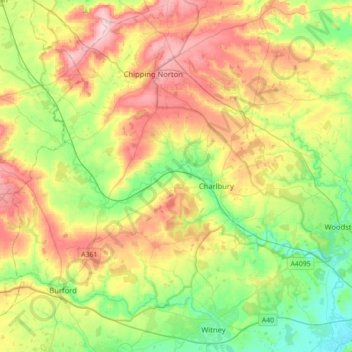
Name: River Evenlode topographic map, elevation, terrain.
Location: River Evenlode, Oxfordshire, England, United Kingdom (51.78428 -1.68930 51.97303 -1.33739)
Average elevation: 453 ft
Minimum elevation: 194 ft
Maximum elevation: 814 ft
Other topographic maps
Click on a map to view its topography, its elevation and its terrain.
Oxford
United Kingdom > England > Oxfordshire
Oxford, Oxfordshire, England, United Kingdom
Average elevation: 266 ft
Glympton
United Kingdom > England > Oxfordshire > West Oxfordshire
Glympton, West Oxfordshire, Oxfordshire, England, United Kingdom
Average elevation: 404 ft
Abingdon
United Kingdom > England > Oxfordshire > Vale of White Horse
Abingdon, Vale of White Horse, Oxfordshire, England, OX14 3UJ, United Kingdom
Average elevation: 210 ft
Newnham Murren
United Kingdom > England > Oxfordshire > South Oxfordshire > Crowmarsh Gifford
Newnham Murren, Crowmarsh, Crowmarsh Gifford, South Oxfordshire, Oxfordshire, England, OX10 8BW, United Kingdom
Average elevation: 194 ft
Charlton-on-Otmoor
United Kingdom > England > Oxfordshire > Cherwell District
Charlton-on-Otmoor, Cherwell District, Oxfordshire, England, United Kingdom
Average elevation: 203 ft
Great Bourton
United Kingdom > England > Oxfordshire > Cherwell District
Great Bourton, Cherwell District, Oxfordshire, England, OX17 1QP, United Kingdom
Average elevation: 387 ft
Maidensgrove
United Kingdom > England > Oxfordshire > South Oxfordshire
Maidensgrove, Pishill with Stonor, South Oxfordshire, Oxfordshire, England, RG9 6HA, United Kingdom
Average elevation: 499 ft
Kingwood Common
United Kingdom > England > Oxfordshire > South Oxfordshire > Highmoor
Kingwood Common, Highmoor, South Oxfordshire, Oxfordshire, England, United Kingdom
Average elevation: 410 ft
Little Coxwell
United Kingdom > England > Oxfordshire > Vale of White Horse
Little Coxwell, Vale of White Horse, Oxfordshire, England, United Kingdom
Average elevation: 364 ft
Finstock
United Kingdom > England > Oxfordshire > West Oxfordshire
Finstock, West Oxfordshire, Oxfordshire, England, United Kingdom
Average elevation: 417 ft
Steventon
United Kingdom > England > Oxfordshire > Vale of White Horse
Steventon, Vale of White Horse, Oxfordshire, England, United Kingdom
Average elevation: 226 ft
Twyford
United Kingdom > England > Oxfordshire > Cherwell District
Twyford, Cherwell District, Oxfordshire, England, OX17 3HS, United Kingdom
Average elevation: 338 ft
Buscot
United Kingdom > England > Oxfordshire > Vale of White Horse
Buscot, Vale of White Horse, Oxfordshire, England, United Kingdom
Average elevation: 266 ft
Woodeaton
United Kingdom > England > Oxfordshire > South Oxfordshire
Woodeaton, South Oxfordshire, Oxfordshire, England, OX3 9TJ, United Kingdom
Average elevation: 236 ft
Shipton-on-Cherwell
United Kingdom > England > Oxfordshire > Cherwell District
Shipton-on-Cherwell, Cherwell District, Oxfordshire, England, OX5 1JN, United Kingdom
Average elevation: 256 ft
Swalcliffe
United Kingdom > England > Oxfordshire > Cherwell District
Swalcliffe, Cherwell District, Oxfordshire, England, United Kingdom
Average elevation: 535 ft
Watlington Hill
United Kingdom > England > Oxfordshire > South Oxfordshire > Watlington
Watlington Hill, Watlington, South Oxfordshire, Oxfordshire, England, United Kingdom
Average elevation: 620 ft
Fringford
United Kingdom > England > Oxfordshire > Cherwell District
Fringford, Cherwell District, Oxfordshire, England, United Kingdom
Average elevation: 325 ft
Noke
United Kingdom > England > Oxfordshire > Cherwell District
Noke, Cherwell District, Oxfordshire, England, United Kingdom
Average elevation: 223 ft
Garford
United Kingdom > England > Oxfordshire > Vale of White Horse
Garford, Vale of White Horse, Oxfordshire, England, United Kingdom
Average elevation: 200 ft
Little Haseley
United Kingdom > England > Oxfordshire > South Oxfordshire > Great Haseley
Little Haseley, Great Haseley, South Oxfordshire, Oxfordshire, England, OX44 7LN, United Kingdom
Average elevation: 240 ft
Baldon Row
United Kingdom > England > Oxfordshire > South Oxfordshire > Toot Baldon
Baldon Row, Toot Baldon, South Oxfordshire, Oxfordshire, England, OX44 9NE, United Kingdom
Average elevation: 240 ft
Harpsden Wood
United Kingdom > England > Oxfordshire > South Oxfordshire > Henley-on-Thames > Harpsden
Harpsden Wood, Harpsden, Henley-on-Thames, South Oxfordshire, Oxfordshire, England, RG9 4AU, United Kingdom
Average elevation: 207 ft
Moulsford
United Kingdom > England > Oxfordshire > South Oxfordshire
Moulsford, South Oxfordshire, Oxfordshire, England, United Kingdom
Average elevation: 220 ft
Wootton
United Kingdom > England > Oxfordshire > West Oxfordshire
Wootton, West Oxfordshire, Oxfordshire, England, United Kingdom
Average elevation: 367 ft
Souldern
United Kingdom > England > Oxfordshire > Cherwell District
Souldern, Cherwell District, Oxfordshire, England, United Kingdom
Average elevation: 377 ft
Hornton
United Kingdom > England > Oxfordshire > Cherwell District
Hornton, Cherwell District, Oxfordshire, England, United Kingdom
Average elevation: 564 ft
Middle Assendon
United Kingdom > England > Oxfordshire > South Oxfordshire
Middle Assendon, Bix and Assendon, South Oxfordshire, Oxfordshire, England, RG9 6AT, United Kingdom
Average elevation: 358 ft
Henley-on-Thames
United Kingdom > England > Oxfordshire > South Oxfordshire
Henley-on-Thames, South Oxfordshire, Oxfordshire, England, RG9 2AN, United Kingdom
Average elevation: 256 ft
Water Eaton
United Kingdom > England > Oxfordshire > Cherwell District
Water Eaton, Gosford and Water Eaton, Cherwell District, Oxfordshire, England, OX2 8HD, United Kingdom
Average elevation: 207 ft
Wardington
United Kingdom > England > Oxfordshire > Cherwell District
Wardington, Cherwell District, Oxfordshire, England, United Kingdom
Average elevation: 410 ft
Stadhampton
United Kingdom > England > Oxfordshire > South Oxfordshire
Stadhampton, South Oxfordshire, Oxfordshire, England, United Kingdom
Average elevation: 200 ft
Clifton Hampden
United Kingdom > England > Oxfordshire > South Oxfordshire > Clifton Hampden
Clifton Hampden, South Oxfordshire, Oxfordshire, England, United Kingdom
Average elevation: 190 ft
Little Lews
United Kingdom > England > Oxfordshire > Vale of White Horse > Ardington
Little Lews, Ardington, Vale of White Horse, Oxfordshire, England, United Kingdom
Average elevation: 600 ft
Merton
United Kingdom > England > Oxfordshire > Cherwell District
Merton, Cherwell District, Oxfordshire, England, United Kingdom
Average elevation: 207 ft
Aston Tirrold
United Kingdom > England > Oxfordshire > South Oxfordshire
Aston Tirrold, South Oxfordshire, Oxfordshire, England, United Kingdom
Average elevation: 276 ft
Botley Stream
United Kingdom > England > Oxfordshire > Oxford
Botley Stream, New Botley, West Oxford, Oxford, Oxfordshire, England, OX2 0ED, United Kingdom
Average elevation: 220 ft
Gatehampton
United Kingdom > England > Oxfordshire > South Oxfordshire > Goring-on-Thames
Gatehampton, Goring-on-Thames, South Oxfordshire, Oxfordshire, England, RG8 9LU, United Kingdom
Average elevation: 289 ft
Sutton Wick
United Kingdom > England > Oxfordshire > Vale of White Horse > Abingdon > Drayton
Sutton Wick, Drayton, Abingdon, Vale of White Horse, Oxfordshire, England, OX14 4HH, United Kingdom
Average elevation: 187 ft
Wet n Wild Oxford
United Kingdom > England > Oxfordshire > South Oxfordshire > Berinsfield
Wet n Wild Oxford, Drayton Road, Berinsfield, Dorchester On Thames, South Oxfordshire, Oxfordshire, England, OX10 7PQ, United Kingdom
Average elevation: 167 ft
Ipsden
United Kingdom > England > Oxfordshire > South Oxfordshire
Ipsden, South Oxfordshire, Oxfordshire, England, United Kingdom
Average elevation: 420 ft
Idbury
United Kingdom > England > Oxfordshire > West Oxfordshire
Idbury, West Oxfordshire, Oxfordshire, England, United Kingdom
Average elevation: 482 ft
Great Park
United Kingdom > England > Oxfordshire > West Oxfordshire > Long Hanborough
Great Park, Blenheim, Long Hanborough, West Oxfordshire, Oxfordshire, England, United Kingdom
Average elevation: 308 ft
Wytham
United Kingdom > England > Oxfordshire > Vale of White Horse
Wytham, Vale of White Horse, Oxfordshire, England, United Kingdom
Average elevation: 269 ft
Fencott
United Kingdom > England > Oxfordshire > Cherwell District
Fencott, Cherwell District, Oxfordshire, England, OX5 2RD, United Kingdom
Average elevation: 200 ft
Epwell
United Kingdom > England > Oxfordshire > Cherwell District
Epwell, Cherwell District, Oxfordshire, England, United Kingdom
Average elevation: 594 ft
Little Wittenham
United Kingdom > England > Oxfordshire > South Oxfordshire
Little Wittenham, South Oxfordshire, Oxfordshire, England, United Kingdom
Average elevation: 200 ft
Spelsbury
United Kingdom > England > Oxfordshire > West Oxfordshire
Spelsbury, West Oxfordshire, Oxfordshire, England, United Kingdom
Average elevation: 492 ft
Nuffield
United Kingdom > England > Oxfordshire > South Oxfordshire
Nuffield, South Oxfordshire, Oxfordshire, England, United Kingdom
Average elevation: 594 ft
Nuneham Courtenay
United Kingdom > England > Oxfordshire > South Oxfordshire
Nuneham Courtenay, South Oxfordshire, Oxfordshire, England, United Kingdom
Average elevation: 226 ft