
Mesa Verde National Park topographic map
Interactive map
Click on the map to display elevation.
Mesa Verde National Park
The early Archaic people living near Mesa Verde utilized the atlatl and harvested a wider variety of plants and animals than the Paleo-Indians had while retaining their primarily nomadic lifestyle. They inhabited the outlying areas of the Mesa Verde region, but also the mountains, mesa tops, and canyons, where they created rock shelters and rock art, and left evidence of animal processing and chert knapping. Environmental stability during the period drove population expansion and migration. Major warming and drying from 5000 to 2500 might have led middle Archaic people to seek the cooler climate of Mesa Verde, whose higher elevation brought increased snowpack that, when coupled with spring rains, provided relatively plentiful amounts of water.
About this map
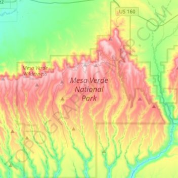
Name: Mesa Verde National Park topographic map, elevation, terrain.
Average elevation: 7,044 ft
Minimum elevation: 5,932 ft
Maximum elevation: 8,566 ft
Montezuma County trails, hiking, mountain biking, running and outdoor activities
Other topographic maps
Click on a map to view its topography, its elevation and its terrain.
Mancos
United States > Colorado > Montezuma County
According to the United States Census Bureau, Mancos has a total area of 0.6 square miles (1.6 km2), all of it recorded as land. The town is located in the Mancos River valley at an elevation of approximately 7,000 feet (2,100 m). The Mancos River was named by Spanish explorers (Rio de los Mancos - "River of…
Average elevation: 7,080 ft
Cortez
United States > Colorado > Montezuma County > Cortez
Cortez has a dry-summer continental climate (Köppen Dsb), though it borders on a semi-arid climate (BSk) due to low precipitation. The city has hot summer days and cold winter nights, the latter a result of its elevation.
Average elevation: 6,132 ft