Geolocate

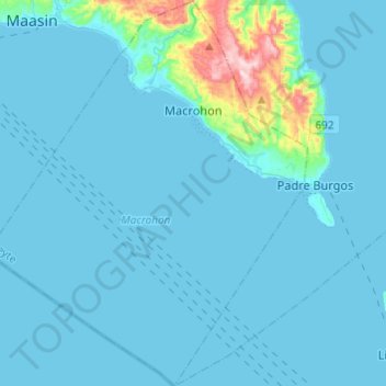
Macrohon topographic map

Click on the map to display elevation.

Macrohon

The town has varying contour elevations. The western portion along the seacoast comprises a level land. The rest of the land area has varying elevations ranging from gently sloping areas, land sloping in one general direction to steeply undulating and rolling land sloping in many directions.

Wikipedia (CC-BY-SA 3.0)

About this map

Name: Macrohon topographic map, elevation, terrain.

Location: Macrohon, Southern Leyte, Eastern Visayas, 6601, Philippines (9.91465 124.80837 10.14466 125.01225)

Average elevation: 115 ft

Minimum elevation: -3 ft

Maximum elevation: 1,535 ft

Other topographic maps

Click on a map to view its topography, its elevation and its terrain.

Tomas Oppus

Philippines > Southern Leyte

Average elevation: 213 ft

Silago

Philippines > Southern Leyte

Average elevation: 348 ft

Mount Cabalian

Philippines > Southern Leyte

The stratovolcano has an elevation of 945 metres (3,100 ft) with a base diameter of 8.5 kilometres (5.3 mi). The predominant rock type is andesite. Beside solfataras, other thermal features present are hot springs located on the east and west flank of the volcano. Mainit Hot Spring in the municipality of…

Average elevation: 1,719 ft

Milagroso

Philippines > Southern Leyte

Average elevation: 643 ft

Bontoc

Philippines > Southern Leyte

Average elevation: 121 ft

Lilo-an

Philippines > Southern Leyte

Average elevation: 102 ft

Saint Bernard

Philippines > Southern Leyte

Average elevation: 328 ft

Pananawan

Philippines > Southern Leyte

Average elevation: 157 ft

Sto. Rosario

Philippines > Southern Leyte

Average elevation: 23 ft

Malitbog

Philippines > Southern Leyte

Average elevation: 249 ft

Hinunangan

Philippines > Southern Leyte

Hinunangan is home to the highest mountain in the province, Mount Nacolod, with an elevation of 948 metres (3,110 ft) above sea level.

Average elevation: 115 ft

Brgy. San Roque

Philippines > Southern Leyte

Average elevation: 417 ft

Anahawan

Philippines > Southern Leyte

Average elevation: 423 ft

Maningning

Philippines > Southern Leyte

Average elevation: 784 ft

Maasin

Philippines > Southern Leyte

Average elevation: 295 ft

Casao

Philippines > Southern Leyte

Average elevation: 138 ft

Sogod

Philippines > Southern Leyte

On May 18, 1700, the colonial government of the Philippines established Sogod as a regular visita [satellite barrio with chapel]. With this elevation, a concrete church finally stood in the settlement in the year 1718. The construction was made possible through the mandate of the Most Reverend Sebastian…

Average elevation: 308 ft

Kahupian

Philippines > Southern Leyte

Average elevation: 1,319 ft

Hinundayan

Philippines > Southern Leyte

Average elevation: 125 ft

Somoje

Philippines > Southern Leyte > San Juan

Average elevation: 285 ft

Cabascan

Philippines > Southern Leyte > Tomas Oppus

Average elevation: 223 ft

Salvador

Philippines > Southern Leyte > Macrohon

Average elevation: 679 ft

Ichon

Philippines > Southern Leyte > Macrohon

Average elevation: 79 ft

Mount Bagacay

Philippines > Southern Leyte > Bagong Silang

Average elevation: 951 ft

Himakilo

Philippines > Southern Leyte > Esperanza

Average elevation: 253 ft

Pagasa

Philippines > Southern Leyte > Tomas Oppus

Average elevation: 135 ft

Biak Na Bato

Philippines > Southern Leyte > Padre Burgos

Average elevation: 279 ft

Baugo

Philippines > Southern Leyte > Maasin

Average elevation: 1,109 ft

Hantag

Philippines > Southern Leyte > Maasin

Average elevation: 604 ft

Sogod Bay

Philippines > Southern Leyte > Lilo-an > Tabugon

Average elevation: 10 ft

Mount Nacolod

Philippines > Southern Leyte

Average elevation: 2,238 ft

Nava

Philippines > Southern Leyte > Hinunangan

Average elevation: 830 ft

San Francisco

Philippines > Southern Leyte

Average elevation: 315 ft

Hinundayan

Philippines > Southern Leyte

Average elevation: 125 ft

Tigbao

Philippines > Southern Leyte > Libagon

Average elevation: 164 ft

Hanginan

Philippines > Southern Leyte > Maasin

Average elevation: 643 ft

Saint Bernard

Philippines > Southern Leyte

Average elevation: 328 ft

Pintuyan

Philippines > Southern Leyte

Average elevation: 351 ft

Matapay

Philippines > Southern Leyte > Maslog

Average elevation: 289 ft

Sogod

Philippines > Southern Leyte

On May 18, 1700, the colonial government of the Philippines established Sogod as a regular visita [satellite barrio with chapel]. With this elevation, a concrete church finally stood in the settlement in the year 1718. The construction was made possible through the mandate of the Most Reverend Sebastian…

Average elevation: 308 ft

Mount Cabalian

Philippines > Southern Leyte

The stratovolcano has an elevation of 945 metres (3,100 ft) with a base diameter of 8.5 kilometres (5.3 mi). The predominant rock type is andesite. Beside solfataras, other thermal features present are hot springs located on the east and west flank of the volcano. Mainit Hot Spring in the municipality of…

Average elevation: 1,719 ft
Hinundayan

Philippines > Southern Leyte

Average elevation: 125 ft

Hinunangan

Philippines > Southern Leyte

Hinunangan is home to the highest mountain in the province, Mount Nacolod, with an elevation of 948 metres (3,110 ft) above sea level.

Average elevation: 115 ft

Santa Filomena

Philippines > Southern Leyte

Average elevation: 440 ft

Pintuyan

Philippines > Southern Leyte

Average elevation: 354 ft

Maasin

Philippines > Southern Leyte

Average elevation: 295 ft

Silago

Philippines > Southern Leyte

Average elevation: 348 ft

Saint Bernard

Philippines > Southern Leyte

Average elevation: 328 ft

Santa Filomena

Philippines > Southern Leyte

Average elevation: 440 ft

Laguma

Philippines > Southern Leyte

Average elevation: 115 ft

Talay

Philippines > Southern Leyte > Tubaon

Average elevation: 177 ft

Bontoc

Philippines > Southern Leyte

Average elevation: 112 ft

Hanginan

Philippines > Southern Leyte > Maasin

Average elevation: 643 ft

Maasin

Philippines > Southern Leyte

Average elevation: 295 ft

Libagon

Philippines > Southern Leyte

Average elevation: 459 ft

Gear up for your next adventure:

🧷Carabiner Set - Durable clips for gear attachment
👖Convertible Hiking Pants - Versatile zip-off pants for changing altitudes and temperatures
🪶Paracord Bracelet - Survival bracelet with built‑in tools
🌐World Map Poster - Decorative world maps with topographic info
🧯Portable Fire Pit - Compact fire pit for camping spots

As an Amazon Associate, this site earns from qualifying purchases at no extra cost to you.