
Hawley topographic map
Interactive map
Click on the map to display elevation.
About this map
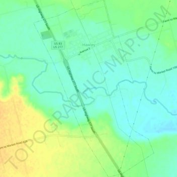
Name: Hawley topographic map, elevation, terrain.
Location: Hawley, Jones County, Texas, United States (32.58062 -99.82931 32.62441 -99.79392)
Average elevation: 1,657 ft
Minimum elevation: 1,617 ft
Maximum elevation: 1,709 ft
Other topographic maps
Click on a map to view its topography, its elevation and its terrain.
Hamlin
United States > Texas > Jones County
Hamlin, Jones County, Texas, 79520, United States
Average elevation: 1,726 ft
Stamford
United States > Texas > Jones County
Stamford, Jones County, Texas, 79553, United States
Average elevation: 1,542 ft
College Lake
United States > Texas > Jones County > Stamford
College Lake, Stamford, Jones County, Texas, United States
Average elevation: 1,568 ft
Hawley
United States > Texas > Jones County > Hawley > Hawley
Hawley, Jones County, Texas, 79525, United States
Average elevation: 1,654 ft