
Make a donation
Gear up for your next adventure:
As an Amazon Associate, this site earns from qualifying purchases at no extra cost to you.
Roxana topographic map
Click on the map to display elevation.
Make a donation
Gear up for your next adventure:
As an Amazon Associate, this site earns from qualifying purchases at no extra cost to you.
About this map
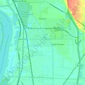
Name: Roxana topographic map, elevation, terrain.
Location: Roxana, Madison County, Illinois, 62084, United States (38.80427 -90.08632 38.85735 -90.00659)
Average elevation: 433 ft
Minimum elevation: 397 ft
Maximum elevation: 574 ft
Madison County trails, hiking, mountain biking, running and outdoor activities
Make a donation
Gear up for your next adventure:
As an Amazon Associate, this site earns from qualifying purchases at no extra cost to you.
Other topographic maps
Click on a map to view its topography, its elevation and its terrain.
Wood River
United States > Illinois > Madison County > Wood River > Wood River
Average elevation: 453 ft
Make a donation
Gear up for your next adventure:
As an Amazon Associate, this site earns from qualifying purchases at no extra cost to you.
Glen Carbon
United States > Illinois > Madison County > Glen Carbon > Glen Carbon
Average elevation: 518 ft
Collinsville
United States > Illinois > Madison County > Collinsville > Collinsville
Average elevation: 522 ft
Make a donation
Gear up for your next adventure:
As an Amazon Associate, this site earns from qualifying purchases at no extra cost to you.