
Make a donation
Gear up for your next adventure:
As an Amazon Associate, this site earns from qualifying purchases at no extra cost to you.
Kimberly topographic map
Click on the map to display elevation.
Make a donation
Gear up for your next adventure:
As an Amazon Associate, this site earns from qualifying purchases at no extra cost to you.
Kimberly
Kimberly is located at 42°31′59″N 114°21′50″W / 42.53306°N 114.36389°W / 42.53306; -114.36389 (42.533169, -114.364022), at an elevation of 3,924 feet (1,196 m) above sea level.
Make a donation
Gear up for your next adventure:
As an Amazon Associate, this site earns from qualifying purchases at no extra cost to you.
About this map
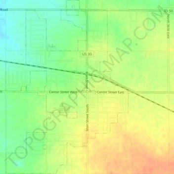
Name: Kimberly topographic map, elevation, terrain.
Location: Kimberly, Twin Falls County, Idaho, 83441, United States (42.51917 -114.38435 42.54991 -114.35492)
Average elevation: 3,921 ft
Minimum elevation: 3,852 ft
Maximum elevation: 3,980 ft
Twin Falls County trails, hiking, mountain biking, running and outdoor activities
Make a donation
Gear up for your next adventure:
As an Amazon Associate, this site earns from qualifying purchases at no extra cost to you.
Other topographic maps
Click on a map to view its topography, its elevation and its terrain.