
Saint-Gervais-les-Bains topographic map
Interactive map
Click on the map to display elevation.
Saint-Gervais-les-Bains
The main railway station for Saint-Gervais is the Gare de Saint-Gervais-les-Bains-Le Fayet. The Mont Blanc Tramway departs from the forecourt of Le Fayet station and reaches the Nid d'Aigle station at the Bionnassay glacier at an altitude of 2,372 m (7,782 ft). The Saint-Gervais–Vallorcine railway, a metre gauge line, departs from Le Fayet station and takes you to Chamonix and across the Swiss border to Martigny. Numerous other destinations throughout France (including direct trains to Paris) can be accessed from the main SNCF station at Le Fayet, and the main resort is just a 10-minute descent to the nearby A40 Peage motorway to Geneva, Lyon, Paris and connecting to the rest of the French motorway network.
About this map
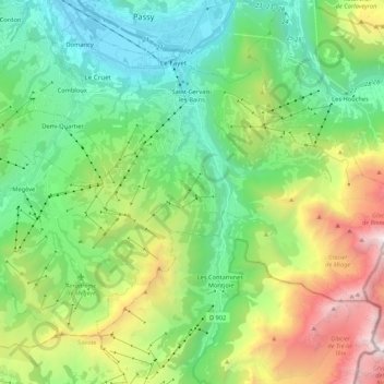
Name: Saint-Gervais-les-Bains topographic map, elevation, terrain.
Average elevation: 5,213 ft
Minimum elevation: 1,785 ft
Maximum elevation: 13,038 ft
Other topographic maps
Click on a map to view its topography, its elevation and its terrain.
Mont Blanc / Monte Bianco
France > Auvergne-Rhône-Alpes > Upper Savoy > Saint-Gervais-les-Bains
The climate is cold and temperate (Köppen climate classification Cfb), and is greatly influenced by altitude. Being the highest part of the Alps, Mont Blanc and surrounding mountains can create their own weather patterns. Temperatures drop as the mountains gain in height, and the summit of Mont Blanc is a…
Average elevation: 13,425 ft
Aiguille du Midi
France > Auvergne-Rhône-Alpes > Upper Savoy > Chamonix-Mont-Blanc
The span of the second section is 2,867 m (1.781 mi) measured directly, but only 2,500 m (1.6 mi) measured horizontally. Thus it remains the second longest span width, measured directly. The cable car travels from Chamonix to the top of the Aiguille du Midi – an altitude gain of over 2,800 m (9,200 ft) –…
Average elevation: 10,164 ft
Mont Joly
France > Auvergne-Rhône-Alpes > Upper Savoy > Saint-Gervais-les-Bains
Average elevation: 6,490 ft
Flaine
France > Auvergne-Rhône-Alpes > Upper Savoy
The site is divided into two areas which are joined by two free lifts. The upper area, Flaine Forêt, at an altitude of 1700 m, consists of a number of apartment buildings named after constellations, the Éric et Sylvie Boissonnas Auditorium, shops, offices and restaurants. The lower area, Flaine Forum, at an…
Average elevation: 6,070 ft
Les Plans
France > Auvergne-Rhône-Alpes > Upper Savoy > Chamonix-Mont-Blanc
Average elevation: 4,646 ft
Vers le Nant
France > Auvergne-Rhône-Alpes > Upper Savoy > Chamonix-Mont-Blanc > Les Bossons
Average elevation: 4,452 ft
Bas-Monthoux
France > Auvergne-Rhône-Alpes > Upper Savoy > Vétraz-Monthoux
Average elevation: 1,585 ft
Montenvers
France > Auvergne-Rhône-Alpes > Upper Savoy > Chamonix-Mont-Blanc
Average elevation: 5,909 ft
Les Frasserands
France > Auvergne-Rhône-Alpes > Upper Savoy > Chamonix-Mont-Blanc > Argentière
Average elevation: 5,591 ft
Argentière
France > Auvergne-Rhône-Alpes > Upper Savoy > Chamonix-Mont-Blanc
Argentière (French pronunciation: [aʁʒɑ̃tjɛʁ]) is a picturesque skiing, alpine walking and mountaineering village in the French Alps, part of the commune of Chamonix-Mont-Blanc, at an altitude of 1,252 m (4,108 ft).
Average elevation: 5,492 ft
Saint-Nicolas-de-Véroce
France > Auvergne-Rhône-Alpes > Upper Savoy > Saint-Gervais-les-Bains
Average elevation: 4,396 ft
Mer de Glace
France > Auvergne-Rhône-Alpes > Upper Savoy > Chamonix-Mont-Blanc
The glacier lies above the Chamonix valley. The pressure within the ice is known to reach at least 30 atmospheres. The Mer de Glace can be considered as originating at an elevation of 2,100 metres (6,900 ft), just north of the Aiguille du Tacul, where it is formed by the confluence of the Glacier de Leschaux…
Average elevation: 7,621 ft
Quincy
France > Auvergne-Rhône-Alpes > Upper Savoy > Clarafond-Arcine > Clarafond
Average elevation: 1,759 ft
Aiguille du Plan
France > Auvergne-Rhône-Alpes > Upper Savoy > Chamonix-Mont-Blanc
Average elevation: 9,695 ft
Mont Blanc / Monte Bianco
France > Auvergne-Rhône-Alpes > Upper Savoy > Saint-Gervais-les-Bains
The climate is cold and temperate (Köppen climate classification Cfb), and is greatly influenced by altitude. Being the highest part of the Alps, Mont Blanc and surrounding mountains can create their own weather patterns. Temperatures drop as the mountains gain in height, and the summit of Mont Blanc is a…
Average elevation: 13,425 ft
La Côte des Chavants
France > Auvergne-Rhône-Alpes > Upper Savoy > Les Houches
Average elevation: 4,393 ft
La Tournette
France > Auvergne-Rhône-Alpes > Upper Savoy > Talloires-Montmin
Average elevation: 5,741 ft
Ternier
France > Auvergne-Rhône-Alpes > Upper Savoy > Saint-Julien-en-Genevois
Average elevation: 1,578 ft
Flaine
France > Auvergne-Rhône-Alpes > Upper Savoy
The site is divided into two areas which are joined by two free lifts. The upper area, Flaine Forêt, at an altitude of 1700 m, consists of a number of apartment buildings named after constellations, the Éric et Sylvie Boissonnas Auditorium, shops, offices and restaurants. The lower area, Flaine Forum, at an…
Average elevation: 6,070 ft
Essert-la-Pierre
France > Auvergne-Rhône-Alpes > Upper Savoy > Saint-Jean-d'Aulps
Average elevation: 3,921 ft
Crêt de Pézollet
France > Auvergne-Rhône-Alpes > Upper Savoy > La Balme-de-Thuy
Average elevation: 4,354 ft
Aiguille du Tacul
France > Auvergne-Rhône-Alpes > Upper Savoy > Chamonix-Mont-Blanc
Average elevation: 9,127 ft
Montenvers
France > Auvergne-Rhône-Alpes > Upper Savoy > Chamonix-Mont-Blanc
Average elevation: 5,909 ft
Aiguille du Jardin
France > Auvergne-Rhône-Alpes > Upper Savoy > Chamonix-Mont-Blanc
Average elevation: 10,676 ft
Mont Blanc / Monte Bianco
France > Auvergne-Rhône-Alpes > Upper Savoy > Saint-Gervais-les-Bains
The climate is cold and temperate (Köppen climate classification Cfb), and is greatly influenced by altitude. Being the highest part of the Alps, Mont Blanc and surrounding mountains can create their own weather patterns. Temperatures drop as the mountains gain in height, and the summit of Mont Blanc is a…
Average elevation: 13,425 ft
Pointe de Nantaux
France > Auvergne-Rhône-Alpes > Upper Savoy > Saint-Jean-d'Aulps
Average elevation: 5,745 ft
Pointe Rousse (du Criou)
France > Auvergne-Rhône-Alpes > Upper Savoy > Samoëns
Average elevation: 6,791 ft
Chamonix-Mont-Blanc
France > Auvergne-Rhône-Alpes > Upper Savoy > Chamonix-Mont-Blanc > Chamonix-Mont-Blanc
Average elevation: 5,863 ft
Les Bossons
France > Auvergne-Rhône-Alpes > Upper Savoy > Chamonix-Mont-Blanc
Average elevation: 4,514 ft
Mont Blanc / Monte Bianco
France > Auvergne-Rhône-Alpes > Upper Savoy > Saint-Gervais-les-Bains
The climate is cold and temperate (Köppen climate classification Cfb), and is greatly influenced by altitude. Being the highest part of the Alps, Mont Blanc and surrounding mountains can create their own weather patterns. Temperatures drop as the mountains gain in height, and the summit of Mont Blanc is a…
Average elevation: 13,425 ft
Nant Borrant
France > Auvergne-Rhône-Alpes > Upper Savoy > Les Contamines-Montjoie
Average elevation: 5,942 ft
Les Bossons
France > Auvergne-Rhône-Alpes > Upper Savoy > Chamonix-Mont-Blanc
Average elevation: 4,514 ft
Col de la Colombière
France > Auvergne-Rhône-Alpes > Upper Savoy > Le Reposoir
Col de la Colombière (elevation 1613 m) is a mountain pass in the Alps in the department of Haute-Savoie in France.
Average elevation: 5,794 ft