
Laurel Springs topographic map
Interactive map
Click on the map to display elevation.
About this map
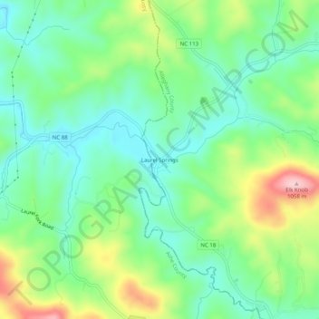
Name: Laurel Springs topographic map, elevation, terrain.
Average elevation: 2,930 ft
Minimum elevation: 2,694 ft
Maximum elevation: 3,428 ft
Alleghany County trails, hiking, mountain biking, running and outdoor activities
Other topographic maps
Click on a map to view its topography, its elevation and its terrain.
New River
United States > North Carolina > Alleghany County
On its journey through the New River Gorge, the New River passes through an extensive geological formation. Emergent rocks and rock outcrops are found to provide diverse habitat producing rich and abundant flora and fauna species. In the gorge, there is typically a 1000 feet difference in elevation between the…
Average elevation: 2,635 ft