
Thank you for supporting this site ❤️
Make a donation
Make a donation
Gear up for your next adventure:
As an Amazon Associate, this site earns from qualifying purchases at no extra cost to you.
Prigorec topographic map
Click on the map to display elevation.
Thank you for supporting this site ❤️
Make a donation
Make a donation
Gear up for your next adventure:
As an Amazon Associate, this site earns from qualifying purchases at no extra cost to you.
About this map
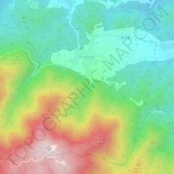
Name: Prigorec topographic map, elevation, terrain.
Location: Prigorec, Grad Ivanec, Varaždin County, Croatia (46.17885 16.10842 46.20888 16.15674)
Average elevation: 1,791 ft
Minimum elevation: 837 ft
Maximum elevation: 3,442 ft
Thank you for supporting this site ❤️
Make a donation
Make a donation
Gear up for your next adventure:
As an Amazon Associate, this site earns from qualifying purchases at no extra cost to you.