
Make a donation
Gear up for your next adventure:
As an Amazon Associate, this site earns from qualifying purchases at no extra cost to you.
Lampa topographic map
Click on the map to display elevation.
Make a donation
Gear up for your next adventure:
As an Amazon Associate, this site earns from qualifying purchases at no extra cost to you.
About this map
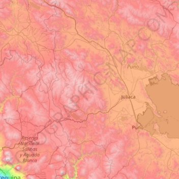
Name: Lampa topographic map, elevation, terrain.
Location: Lampa, Puno, Peru (-16.41667 -71.58333 -14.41667 -69.58333)
Average elevation: 13,914 ft
Minimum elevation: 7,667 ft
Maximum elevation: 19,462 ft
Make a donation
Gear up for your next adventure:
As an Amazon Associate, this site earns from qualifying purchases at no extra cost to you.
Other topographic maps
Click on a map to view its topography, its elevation and its terrain.
Titicacasee
Der Titicacasee ist das höchstgelegene kommerziell schiffbare Gewässer der Erde. Er liegt auf einer Höhe von 3812 m über dem Meeresspiegel, ist 178 km lang und bis 67,4 km breit und hat eine durchschnittliche Tiefe von 107 m. In den See ragen mehrere Halbinseln, bei der Copacabana-Halbinsel verbindet nur…
Average elevation: 12,697 ft
Make a donation
Gear up for your next adventure:
As an Amazon Associate, this site earns from qualifying purchases at no extra cost to you.
Sandia
Die Provinz Sandia liegt im Nordosten der Region Puno. Die Längsausdehnung in SSW-NNO-Richtung beträgt 200 km, die durchschnittliche Breite liegt bei etwa 60 km. Die Provinz erstreckt sich im Süden über einen 65 km langen Abschnitt der Cordillera Carabaya, ein Gebirgszug der peruanischen Ostkordillere. Im…
Average elevation: 5,607 ft
Make a donation
Gear up for your next adventure:
As an Amazon Associate, this site earns from qualifying purchases at no extra cost to you.