
Make a donation
Gear up for your next adventure:
As an Amazon Associate, this site earns from qualifying purchases at no extra cost to you.
Zepita topographic map
Click on the map to display elevation.
Make a donation
Gear up for your next adventure:
As an Amazon Associate, this site earns from qualifying purchases at no extra cost to you.
About this map
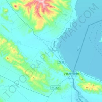
Name: Zepita topographic map, elevation, terrain.
Location: Zepita, Chucuito, Puno, Peru (-16.64699 -69.32220 -16.35061 -69.04248)
Average elevation: 12,808 ft
Minimum elevation: 12,484 ft
Maximum elevation: 15,745 ft
Make a donation
Gear up for your next adventure:
As an Amazon Associate, this site earns from qualifying purchases at no extra cost to you.
Other topographic maps
Click on a map to view its topography, its elevation and its terrain.
La Rinconada
Die Stadt befindet sich im Distrikt Ananea der Provinz San Antonio de Putina auf einer Höhe von bis zu 5100 m an der Südflanke der Cordillera Apolobamba, eines Gebirgszuges der peruanischen Ostkordillere. Etwa 2,5 km weiter westlich liegt der See Laguna Rinconada.
Average elevation: 16,152 ft
Make a donation
Gear up for your next adventure:
As an Amazon Associate, this site earns from qualifying purchases at no extra cost to you.
Make a donation
Gear up for your next adventure:
As an Amazon Associate, this site earns from qualifying purchases at no extra cost to you.