
Make a donation
Gear up for your next adventure:
As an Amazon Associate, this site earns from qualifying purchases at no extra cost to you.
Sandia topographic map
Click on the map to display elevation.
Make a donation
Gear up for your next adventure:
As an Amazon Associate, this site earns from qualifying purchases at no extra cost to you.
Sandia
Die Provinz Sandia liegt im Nordosten der Region Puno. Die Längsausdehnung in SSW-NNO-Richtung beträgt 200 km, die durchschnittliche Breite liegt bei etwa 60 km. Die Provinz erstreckt sich im Süden über einen 65 km langen Abschnitt der Cordillera Carabaya, ein Gebirgszug der peruanischen Ostkordillere. Im zentralen Teil der Provinz liegen die vorandinen Höhenkämme, nördlich davon das vorgelagerte Amazonastiefland. Die Provinz liegt fast vollständig im Einzugsgebiet des Río Madre de Dios. Der Río Inambari entwässert den südlichen Bereich der Provinz, der Río Tambopata fließt quer (von Südosten nach Nordwesten) über den nördlichen Bereich der Provinz. Der Río Heath verläuft entlang der nördlichen Ostgrenze der Provinz. Der Oberlauf des Río Ramis (auch Río Carabaya), ein Zufluss des Titicacasees, verläuft ein kurzes Stück entlang der südlichen Provinzgrenze.
Make a donation
Gear up for your next adventure:
As an Amazon Associate, this site earns from qualifying purchases at no extra cost to you.
About this map
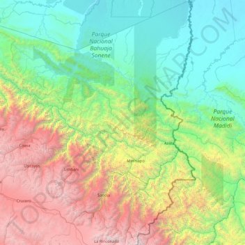
Name: Sandia topographic map, elevation, terrain.
Location: Sandia, Puno, 21101, Peru (-14.66193 -69.84857 -13.00413 -68.82668)
Average elevation: 5,607 ft
Minimum elevation: 627 ft
Maximum elevation: 19,711 ft
Make a donation
Gear up for your next adventure:
As an Amazon Associate, this site earns from qualifying purchases at no extra cost to you.
Other topographic maps
Click on a map to view its topography, its elevation and its terrain.
La Rinconada
Die Stadt befindet sich im Distrikt Ananea der Provinz San Antonio de Putina auf einer Höhe von bis zu 5100 m an der Südflanke der Cordillera Apolobamba, eines Gebirgszuges der peruanischen Ostkordillere. Etwa 2,5 km weiter westlich liegt der See Laguna Rinconada.
Average elevation: 16,152 ft
Make a donation
Gear up for your next adventure:
As an Amazon Associate, this site earns from qualifying purchases at no extra cost to you.
Make a donation
Gear up for your next adventure:
As an Amazon Associate, this site earns from qualifying purchases at no extra cost to you.