
Calf of Man topographic map
Interactive map
Click on the map to display elevation.
About this map
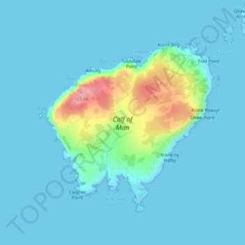
Name: Calf of Man topographic map, elevation, terrain.
Location: Calf of Man, Rushen, Isle of Man (54.04385 -4.83085 54.06172 -4.79938)
Average elevation: 52 ft
Minimum elevation: -3 ft
Maximum elevation: 404 ft
Other topographic maps
Click on a map to view its topography, its elevation and its terrain.
Ballasalla
Isle of Man > Rushen > Malew
Ballasalla, Malew, Rushen, Isle of Man
Average elevation: 128 ft
Ronague
Isle of Man > Rushen > Arbory > Ronague
Ronague, Arbory, Rushen, IM9 4HQ, Isle of Man
Average elevation: 492 ft