
Port Saint Mary topographic map
Interactive map
Click on the map to display elevation.
About this map
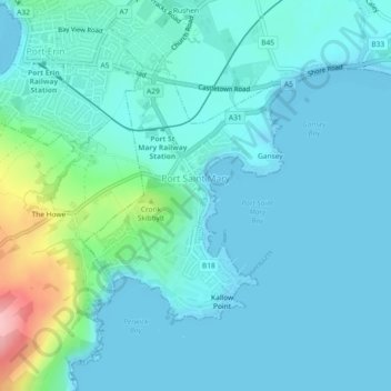
Name: Port Saint Mary topographic map, elevation, terrain.
Location: Port Saint Mary, Rushen, Isle of Man (54.06716 -4.75236 54.08490 -4.72826)
Average elevation: 79 ft
Minimum elevation: 0 ft
Maximum elevation: 528 ft
Other topographic maps
Click on a map to view its topography, its elevation and its terrain.
Ballasalla
Isle of Man > Rushen > Malew
Ballasalla, Malew, Rushen, Isle of Man
Average elevation: 128 ft
Ronague
Isle of Man > Rushen > Arbory > Ronague
Ronague, Arbory, Rushen, IM9 4HQ, Isle of Man
Average elevation: 492 ft