Geolocate

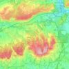
Fetcham topographic map

Click on the map to display elevation.

About this map

Name: Fetcham topographic map, elevation, terrain.

Location: Fetcham, Mole Valley, Surrey, England, KT22 9JD, United Kingdom (51.27602 -0.37624 51.31602 -0.33624)

Average elevation: 161 ft

Minimum elevation: 69 ft

Maximum elevation: 381 ft

Other topographic maps

Click on a map to view its topography, its elevation and its terrain.
Dorking

United Kingdom > England > Surrey > Mole Valley

Average elevation: 262 ft

Leatherhead

United Kingdom > England > Surrey > Mole Valley

Average elevation: 177 ft

Capel

United Kingdom > England > Surrey > Mole Valley > Capel

Average elevation: 335 ft

Charlwood

United Kingdom > England > Surrey > Mole Valley > Charlwood

Average elevation: 236 ft

Betchworth

United Kingdom > England > Surrey > Mole Valley

Average elevation: 266 ft

Mickleham

United Kingdom > England > Surrey > Mole Valley > Mickleham

Average elevation: 338 ft

Newdigate

United Kingdom > England > Surrey > Mole Valley

Average elevation: 282 ft

Headley

United Kingdom > England > Surrey > Mole Valley

Average elevation: 479 ft

Ockley

United Kingdom > England > Surrey > Mole Valley > Ockley

Average elevation: 295 ft

Brockham

United Kingdom > England > Surrey > Mole Valley

Average elevation: 240 ft

Headley Heath

United Kingdom > England > Surrey > Mole Valley > Headley

Average elevation: 535 ft

Leigh

United Kingdom > England > Surrey > Mole Valley > Leigh

Average elevation: 207 ft

Wotton

United Kingdom > England > Surrey > Mole Valley

Average elevation: 443 ft

Ranmore Common

United Kingdom > England > Surrey > Mole Valley > Westcott

Average elevation: 453 ft

Wallis Wood

United Kingdom > England > Surrey > Mole Valley > Walliswood

Average elevation: 249 ft

Mickleham

United Kingdom > England > Surrey > Mole Valley > Mickleham

Average elevation: 338 ft

Dorking

United Kingdom > England > Surrey > Mole Valley

Average elevation: 262 ft

Ranmore Common

United Kingdom > England > Surrey > Mole Valley

Average elevation: 453 ft

Gear up for your next adventure:

🌡️Portable Weather Meter - Track weather conditions on the trail
🔭Stargazing Telescopes - Perfect for camping in low-light pollution areas shown on maps
🔥Plasma Lighters - Windproof lighters that work in any weather condition
👓Polarized Sunglasses - Outdoor sunglasses for glare reduction
🕶️GPS Smartphone Mount - Secure mount for phone navigation

As an Amazon Associate, this site earns from qualifying purchases at no extra cost to you.