Geolocate

Bitton topographic map

Click on the map to display elevation.

About this map

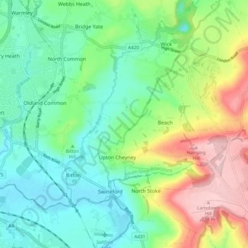
Name: Bitton topographic map, elevation, terrain.

Location: Bitton, South Gloucestershire, West of England, England, United Kingdom (51.41591 -2.49289 51.45444 -2.40260)

Average elevation: 272 ft

Minimum elevation: 23 ft

Maximum elevation: 797 ft

Other topographic maps

Click on a map to view its topography, its elevation and its terrain.

Yate Rocks

United Kingdom > England > South Gloucestershire > Yate

Average elevation: 276 ft

The Folly

United Kingdom > England > South Gloucestershire

Average elevation: 545 ft

Wick

United Kingdom > England > South Gloucestershire

Average elevation: 299 ft

Nibley

United Kingdom > England > South Gloucestershire

Average elevation: 226 ft

Dyrham

United Kingdom > England > South Gloucestershire

Average elevation: 456 ft

Frenchay

United Kingdom > England > South Gloucestershire

Average elevation: 184 ft

Moorend

United Kingdom > England > South Gloucestershire

Average elevation: 174 ft

Kingswood

United Kingdom > England > South Gloucestershire

Average elevation: 187 ft

Warmley

United Kingdom > England > South Gloucestershire

Average elevation: 226 ft

Hambrook

United Kingdom > England > South Gloucestershire

Average elevation: 177 ft

Catbrain

United Kingdom > England > South Gloucestershire

Average elevation: 167 ft

Kingswood

United Kingdom > England > South Gloucestershire

Average elevation: 187 ft

Kingswood

United Kingdom > England > South Gloucestershire

Average elevation: 187 ft

Swineford

United Kingdom > England > South Gloucestershire

Average elevation: 220 ft

Kingswood

United Kingdom > England > South Gloucestershire

Average elevation: 187 ft

Moorend

United Kingdom > England > South Gloucestershire

Average elevation: 174 ft

Kingswood

United Kingdom > England > South Gloucestershire

Average elevation: 187 ft

Gear up for your next adventure:

🦟Ultrasonic Repellers - Create a bug-free zone at your camp or rest stop
🎒Waterproof Dry Bags - Keep your electronics and maps dry inside your pack
🚗GPS Dash Cams - Record your scenic drives through mountain passes and canyons
🩹Survival Bandages - High‑quality bandages for emergencies
📌Outdoor GPS Map App - Apps and devices for digital topographic navigation

As an Amazon Associate, this site earns from qualifying purchases at no extra cost to you.