Geolocate

Engine Common topographic map

Click on the map to display elevation.

About this map

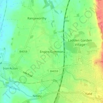
Name: Engine Common topographic map, elevation, terrain.

Location: Engine Common, South Gloucestershire, West of England, England, BS37 7LL, United Kingdom (51.53670 -2.45655 51.57670 -2.41655)

Average elevation: 230 ft

Minimum elevation: 161 ft

Maximum elevation: 344 ft

Other topographic maps

Click on a map to view its topography, its elevation and its terrain.

Aust

United Kingdom > England > South Gloucestershire

Average elevation: 30 ft

Hanham

United Kingdom > England > South Gloucestershire > Kingswood

Average elevation: 233 ft

Filton

United Kingdom > England > South Gloucestershire

Average elevation: 220 ft

Tormarton

United Kingdom > England > South Gloucestershire

Average elevation: 522 ft

Wickwar

United Kingdom > England > South Gloucestershire

Average elevation: 236 ft

Yate

United Kingdom > England > South Gloucestershire

Average elevation: 272 ft

Siston

United Kingdom > England > South Gloucestershire

Average elevation: 262 ft

Thornbury

United Kingdom > England > South Gloucestershire

Average elevation: 141 ft

Bitton

United Kingdom > England > South Gloucestershire

Average elevation: 272 ft

Badminton

United Kingdom > England > South Gloucestershire

Average elevation: 436 ft

Cromhall

United Kingdom > England > South Gloucestershire

Average elevation: 210 ft

Horton

United Kingdom > England > South Gloucestershire

Average elevation: 433 ft

Sodbury

United Kingdom > England > South Gloucestershire

Average elevation: 400 ft

Charfield

United Kingdom > England > South Gloucestershire

Average elevation: 180 ft

Falfield

United Kingdom > England > South Gloucestershire

Average elevation: 161 ft

Olveston

United Kingdom > England > South Gloucestershire

Average elevation: 102 ft

Pucklechurch

United Kingdom > England > South Gloucestershire

The land of Pucklechurch is relatively prominent in elevation compared to surrounding areas and as such it was selected in the Bronze Age as the site of a tumulus (round barrow) at Shortwood Hill.

Average elevation: 322 ft

Dodington

United Kingdom > England > South Gloucestershire

Average elevation: 463 ft

Doynton

United Kingdom > England > South Gloucestershire

Average elevation: 423 ft

Pucklechurch

United Kingdom > England > South Gloucestershire

Shortwood is located to the east of the A4174 and to the west of Pucklechurch village, sitting lower in the landscape topography against the Pucklechurch ridge and adjacent to Emerson’s Green and Mangotsfield. It is largely a linear settlement (comprising approximately 73 households) washed over by the Green…

Average elevation: 322 ft

Thornbury

United Kingdom > England > South Gloucestershire

Average elevation: 141 ft

Yate

United Kingdom > England > South Gloucestershire

Average elevation: 272 ft

Gear up for your next adventure:

📌Outdoor GPS Map App - Apps and devices for digital topographic navigation
🪶Trail Camera - Capture wildlife on your hikes
🥇GPS Hiking Watch - Multi‑sport GPS watch with navigation and trail tracking
🗃️Trail First Aid Kit - Essential kit for outdoor injuries and emergencies
🖼️Topo Map Wall Art - Decorative topographic prints of famous peaks and regions

As an Amazon Associate, this site earns from qualifying purchases at no extra cost to you.