Geolocate

Namora topographic map

Click on the map to display elevation.

About this map

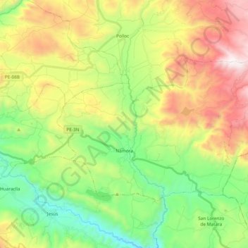
Name: Namora topographic map, elevation, terrain.

Location: Namora, Province of Cajamarca, Cajamarca, Peru (-7.23945 -78.37605 -7.12452 -78.18925)

Average elevation: 9,984 ft

Minimum elevation: 7,930 ft

Maximum elevation: 13,182 ft

Other topographic maps

Click on a map to view its topography, its elevation and its terrain.

Callancas

Peru > Cajamarca > San Pablo

Average elevation: 9,921 ft

Santa Cruz

Peru > Cajamarca

Average elevation: 1,677 ft

El Cardon

Peru > Cajamarca > Cutervo

Average elevation: 7,598 ft

Cruz De Chalpon

Peru > Cajamarca > San Ignacio

Average elevation: 4,882 ft

Regalado

Peru > Cajamarca > Tumbaden

Average elevation: 10,840 ft

Alto Otuzco

Peru > Cajamarca > Los Baños del Inca > Otuzco

Average elevation: 9,275 ft

Yube

Peru > Cajamarca > Callayuc

Average elevation: 5,213 ft

Gear up for your next adventure:

🧭Orienteering Set - Complete compass and map reading kit
🛰️Satellite Messengers - Emergency SOS and two-way messaging for off-grid adventures
🚁Photography Drones - Capture stunning aerial views of landforms and topography
🧦Merino Wool Socks - Moisture-wicking, blister-preventing socks for long treks
🧺Microfiber Travel Towels - Compact and fast-drying towels for trail use

As an Amazon Associate, this site earns from qualifying purchases at no extra cost to you.