
Erlangen topographic map
Click on the map to display elevation.
Erlangen
In 1435 the church, which had been the daughter church of St. Martin in Forchheim up until this point, was elevated to its own parish. The main task of the Erlangen priest was the pastoral care in the city of Erlangen and the St. Martin's Chapel on the Martinsbühl, which was now named for the first time. Furthermore, the document of elevation determines the pastoral care of the surrounding villages of Bubenreuth, Bräuningshof, Marloffstein, Spardorf and Sieglitzhof, whose inhabitants visited the chapel of the Virgin Mary, were pastorally cared for from this chapel and were provided with the sacraments. This addition confirms that there was at least one vicar at the Frauenkirche (Church of Our Lady) before it was elevated to a parish church. The ecclesiastical life was accordingly pronounced and varied at the time. In addition to the parish priest, there were two vicars for the early and middle mass. Whether the financially very badly equipped Mass Beneficiaries were always occupied is not known. With the introduction of the Reformation by Margrave George the Pious in 1528 in Erlangen, the Catholic life of the church was extinguished completely for many years. Only few things from this time remain today: five figures of saints from the former Marienkirche, which today are placed on the northern altar wall in the Altstädter Trinity Church, a measuring cup and the equestrian statue of Saint Martin, which is exhibited annually on St. Martin's Day in the Martinsbühler church.
About this map
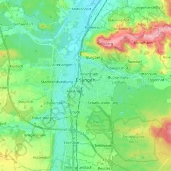
Name: Erlangen topographic map, elevation, terrain.
Location: Erlangen, Bavaria, Germany (49.53271 10.91536 49.64558 11.05360)
Average elevation: 991 ft
Minimum elevation: 866 ft
Maximum elevation: 1,296 ft
Other topographic maps
Click on a map to view its topography, its elevation and its terrain.
Spornhof
Germany > Bavaria > Landkreis Berchtesgadener Land > Berchtesgaden > Unterau
Average elevation: 2,671 ft
Zugspitze
Germany > Bavaria > Landkreis Garmisch-Partenkirchen > Grainau
The mountain rises eleven kilometres southwest of Garmisch-Partenkirchen and just under six kilometres east of Ehrwald. The border between Germany and Austria runs over the west summit; thus the Zugspitze massif belongs to the German state of Bavaria and the Austrian state of Tyrol. The municipalities…
Average elevation: 7,546 ft
Whirlpool
Germany > Bavaria > Landkreis Starnberg > Gauting > Königswiesen
Average elevation: 1,932 ft
Neuschwanstein Castle
Germany > Bavaria > Landkreis Ostallgäu > Hohenschwangau
The municipality of Schwangau lies at an elevation of 800 m (2,620 ft) at the southwest border of the German state of Bavaria. Its surroundings are characterised by the transition between the Alpine foothills in the south (toward the nearby Austrian border) and a hilly landscape in the north that appears flat…
Average elevation: 3,222 ft
Partnach Gorge
Germany > Bavaria > Landkreis Garmisch-Partenkirchen > Garmisch-Partenkirchen > Vordergraseck
Average elevation: 3,291 ft
Stockerbichl
Germany > Bavaria > Landkreis Starnberg > Tutzing > Unterzeismering
Average elevation: 2,080 ft
Lidorf
Germany > Bavaria > Landkreis Rottal-Inn > Mitterskirchen > Mitterskirchen
Average elevation: 1,503 ft
Erlangen
In 1435 the church, which had been the daughter church of St. Martin in Forchheim up until this point, was elevated to its own parish. The main task of the Erlangen priest was the pastoral care in the city of Erlangen and the St. Martin's Chapel on the Martinsbühl, which was now named for the first time.…
Average elevation: 1,086 ft
Obersalzberg
Germany > Bavaria > Landkreis Berchtesgadener Land > Berchtesgaden
Average elevation: 3,061 ft
Neuschwanstein Castle
Germany > Bavaria > Landkreis Ostallgäu > Hohenschwangau
The municipality of Schwangau lies at an elevation of 800 m (2,620 ft) at the southwest border of the German state of Bavaria. Its surroundings are characterised by the transition between the Alpine foothills in the south (toward the nearby Austrian border) and a hilly landscape in the north that appears flat…
Average elevation: 3,222 ft
Immenstadt im Allgäu
Germany > Bavaria > Landkreis Oberallgäu > Immenstadt im Allgäu
Average elevation: 2,986 ft
Aletsberg
Germany > Bavaria > Landkreis Deggendorf > Deggendorf > Oberkandelbach
Average elevation: 1,138 ft
Zugspitze
Germany > Bavaria > Landkreis Garmisch-Partenkirchen > Grainau
The mountain rises eleven kilometres southwest of Garmisch-Partenkirchen and just under six kilometres east of Ehrwald. The border between Germany and Austria runs over the west summit; thus the Zugspitze massif belongs to the German state of Bavaria and the Austrian state of Tyrol. The municipalities…
Average elevation: 7,546 ft
Michelau i.Steigerwald
Germany > Bavaria > Landkreis Schweinfurt > Michelau i.Steigerwald
Average elevation: 1,093 ft
Bayreuth
In most places there is a signed cycle path network. In the centre of Bayreuth itself, cycling is fairly straightforward due to the relatively flat topography, something which encourages the use bicycles as an everyday means of transport. Because of the proximity of the 600 kilometre long Main Cycle Path,…
Average elevation: 1,237 ft
Wind
Germany > Bavaria > Landkreis Bamberg
Winds can shape landforms, via a variety of aeolian processes such as the formation of fertile soils, for example loess, and by erosion. Dust from large deserts can be moved great distances from its source region by the prevailing winds; winds that are accelerated by rough topography and associated with dust…
Average elevation: 932 ft
Riedlhütte
Germany > Bavaria > Landkreis Freyung-Grafenau > Sankt Oswald-Riedlhütte
Average elevation: 2,444 ft
Listsee
Germany > Bavaria > Landkreis Berchtesgadener Land > Bad Reichenhall
Average elevation: 2,615 ft
Partnach Gorge
Germany > Bavaria > Landkreis Garmisch-Partenkirchen > Garmisch-Partenkirchen > Vordergraseck
Average elevation: 3,294 ft
Hopfensee-Achen
Germany > Bavaria > Landkreis Ostallgäu > Füssen > Hopfen am See
Average elevation: 2,654 ft
5er-Grube
Germany > Bavaria > Landkreis Starnberg > Krailling > Kraillinger Innovations Meile KIM
Average elevation: 1,844 ft
Oberjettenberg
Germany > Bavaria > Landkreis Berchtesgadener Land > Schneizlreuth
Average elevation: 2,598 ft
Bad Neustadt an der Saale
Germany > Bavaria > Landkreis Rhön-Grabfeld > Bad Neustadt an der Saale
Average elevation: 938 ft
Kellmünz an der Iller
Germany > Bavaria > Landkreis Neu-Ulm > Kellmünz a.d.Iller
Average elevation: 1,844 ft
Drosendorf an der Aufseß
Germany > Bavaria > Landkreis Bayreuth > Hollfeld
Average elevation: 1,460 ft
Ruine Falkenstein
Germany > Bavaria > Landkreis Ostallgäu > Pfronten > Benken
Originally known as Castrum Pfronten, the stone castle was built approximately 1270–1280 by Count Meinhard II of Tyrol on the borders of his land. Because of the unusual situation of the castle it has been interpreted in historical context as a symbol of opposition to the Duchy of Bavaria. (During the winter…
Average elevation: 3,084 ft
Königshaus am Schachen
Germany > Bavaria > Landkreis Garmisch-Partenkirchen > Garmisch-Partenkirchen
The King's House on Schachen is located at Schachen, at an altitude with a view of the dramatic mountain backdrop of the Wetterstein Formation, about 10 km south of Garmisch-Partenkirchen, Bavaria. It can only be reached via a 10 km forest road, or a three-hour hike, ascending 1000m either from Schloss Elmau…
Average elevation: 5,344 ft
Neumühle
Germany > Bavaria > Landkreis Neustadt an der Waldnaab > Hammerles
Average elevation: 1,516 ft
Kramerspitz
Germany > Bavaria > Landkreis Garmisch-Partenkirchen > Garmisch-Partenkirchen
Average elevation: 4,718 ft
Burgstall
Germany > Bavaria > Landkreis Erlangen-Höchstadt > Herzogenaurach
Average elevation: 1,099 ft
Geroldsee (Wagenbrüchsee)
Germany > Bavaria > Landkreis Garmisch-Partenkirchen > Gerold
Average elevation: 3,412 ft
Schloss Sinning
Germany > Bavaria > Landkreis Neuburg-Schrobenhausen > Sinning
Average elevation: 1,417 ft
Scheuerhof
Germany > Bavaria > Landkreis Pfaffenhofen an der Ilm > Geisenfeld > Parleiten
Average elevation: 1,280 ft
Hinterkaifeck
Germany > Bavaria > Landkreis Neuburg-Schrobenhausen > Gröbern
Average elevation: 1,388 ft
Waginger See
Germany > Bavaria > Landkreis Traunstein > Waginger See > Fisching
Waginger See is a lake in the Alpine foothills, Bavaria, Germany. Geologically, it forms one single lake with the Tachinger See, with which it is connected through a narrow strait at Tettenhausen. The surface area of the Waginger See proper is 6.61 km2 (2.55 sq mi); combined with the Tachinger See it is 8.97…
Average elevation: 1,522 ft
Wermerichshausen
Germany > Bavaria > Landkreis Bad Kissingen > Münnerstadt
Average elevation: 1,024 ft