
Make a donation
Gear up for your next adventure:
As an Amazon Associate, this site earns from qualifying purchases at no extra cost to you.
el Lloar topographic map
Click on the map to display elevation.
Make a donation
Gear up for your next adventure:
As an Amazon Associate, this site earns from qualifying purchases at no extra cost to you.
About this map
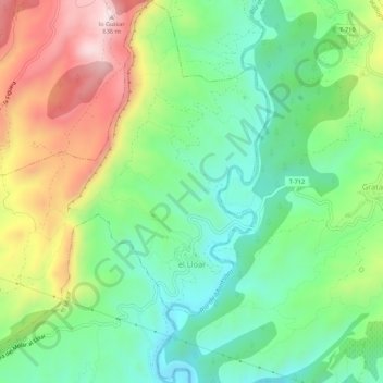
Name: el Lloar topographic map, elevation, terrain.
Location: el Lloar, Priorato, Tarragona, Cataluña, 43737, España (41.17281 0.71234 41.21290 0.76098)
Average elevation: 978 ft
Minimum elevation: 331 ft
Maximum elevation: 2,060 ft
Make a donation
Gear up for your next adventure:
As an Amazon Associate, this site earns from qualifying purchases at no extra cost to you.
Other topographic maps
Click on a map to view its topography, its elevation and its terrain.
Parc Natural de la Serra de Montsant
España > Cataluña > Priorato > la Morera de Montsant
La cima de la Roca Corbatera de 1163 metros es la máxima altitud del parque.
Average elevation: 1,955 ft
Make a donation
Gear up for your next adventure:
As an Amazon Associate, this site earns from qualifying purchases at no extra cost to you.
Cornudella de Montsant
España > Cataluña > Priorato > Cornudella de Montsant > Cornudella de Montsant
Average elevation: 1,916 ft
Presa del Pantà de Siurana
España > Cataluña > Priorato > Cornudella de Montsant
Average elevation: 1,680 ft