Geolocate

Paysandú topographic map

Interactive map

Click on the map to display elevation.

About this map

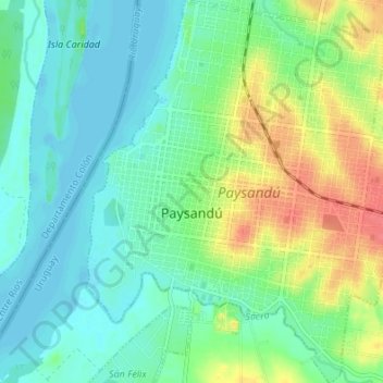
Name: Paysandú topographic map, elevation, terrain.

Location: Paysandú, 60000, Uruguay (-32.34733 -58.10785 -32.29003 -58.05036)

Average elevation: 62 ft

Minimum elevation: -3 ft

Maximum elevation: 197 ft

Other topographic maps

Click on a map to view its topography, its elevation and its terrain.

Cerro Chato

Uruguay > Paysandú

Cerro Chato, Paysandú, 60001, Uruguay

Average elevation: 315 ft

Estación Porvenir

Uruguay > Paysandú

Estación Porvenir, Paysandú, 60000, Uruguay

Average elevation: 240 ft

Sacra

Uruguay > Paysandú > Paysandú

Sacra, Paysandú, 60000, Uruguay

Average elevation: 75 ft

Federación

Uruguay > Paysandú

Federación, Paysandú, 60000, Uruguay

Average elevation: 279 ft