Geolocate

Province of San Marcos topographic map

Click on the map to display elevation.

About this map

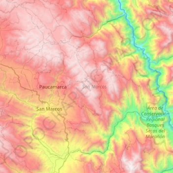
Name: Province of San Marcos topographic map, elevation, terrain.

Location: Province of San Marcos, Cajamarca, 06321, Peru (-7.48053 -78.32558 -7.06477 -77.82891)

Average elevation: 9,131 ft

Minimum elevation: 3,018 ft

Maximum elevation: 14,081 ft

Other topographic maps

Click on a map to view its topography, its elevation and its terrain.

Callancas

Peru > Cajamarca > San Pablo

Average elevation: 9,921 ft

Santa Cruz

Peru > Cajamarca

Average elevation: 1,677 ft

El Cardon

Peru > Cajamarca > Cutervo

Average elevation: 7,598 ft

Cruz De Chalpon

Peru > Cajamarca > San Ignacio

Average elevation: 4,882 ft

Regalado

Peru > Cajamarca > Tumbaden

Average elevation: 10,840 ft

Alto Otuzco

Peru > Cajamarca > Los Baños del Inca > Otuzco

Average elevation: 9,275 ft

Yube

Peru > Cajamarca > Callayuc

Average elevation: 5,213 ft

Gear up for your next adventure:

💧Water Filtration Bottles - Safely drink from streams and lakes while exploring
🪓Survival Multi‑Tool - Versatile tool for camp and trail tasks
🦟Ultrasonic Repellers - Create a bug-free zone at your camp or rest stop
🏫Relief Map Kits - Hands-on tools for teaching landforms and elevation
Camping Coffee Makers - Enjoy premium coffee at the summit or campsite

As an Amazon Associate, this site earns from qualifying purchases at no extra cost to you.