Geolocate

Unaka Mountains topographic map

Click on the map to display elevation.

About this map

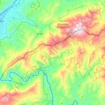
Name: Unaka Mountains topographic map, elevation, terrain.

Location: Unaka Mountains, Mitchell County, East Tennessee, North Carolina, United States (36.07630 -82.41512 36.13594 -82.25362)

Average elevation: 2,982 ft

Minimum elevation: 1,647 ft

Maximum elevation: 5,151 ft

Mitchell County trails, hiking, mountain biking, running and outdoor activities

Other topographic maps

Click on a map to view its topography, its elevation and its terrain.

Relief

United States > North Carolina > Mitchell County

Average elevation: 2,411 ft

Carvers Gap

United States > North Carolina > Mitchell County

Average elevation: 5,203 ft

Buladean

United States > North Carolina > Mitchell County

Average elevation: 3,255 ft

Altapass

United States > North Carolina > Mitchell County

Average elevation: 2,802 ft

Big Bald

United States > North Carolina > Mitchell County

Average elevation: 4,367 ft

Penland

United States > North Carolina > Mitchell County

Average elevation: 2,792 ft

Tipton Hill

United States > North Carolina > Mitchell County

Average elevation: 2,487 ft

Devils Nest

United States > North Carolina > Mitchell County

Average elevation: 3,448 ft

Estatoe

United States > North Carolina > Mitchell County

Average elevation: 2,923 ft

Gear up for your next adventure:

📌Outdoor GPS Map App - Apps and devices for digital topographic navigation
🛰️Satellite Messengers - Emergency SOS and two-way messaging for off-grid adventures
👖Convertible Hiking Pants - Versatile zip-off pants for changing altitudes and temperatures
🧯Portable Fire Pit - Compact fire pit for camping spots
🧭GPS Watch Accessories - Bands and chargers for GPS watches

As an Amazon Associate, this site earns from qualifying purchases at no extra cost to you.