Geolocate

New Deal topographic map

Click on the map to display elevation.

About this map

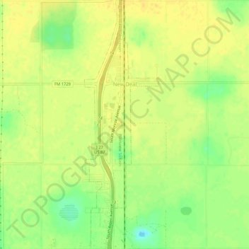
Name: New Deal topographic map, elevation, terrain.

Location: New Deal, Lubbock County, Texas, 79350, United States (33.70837 -101.84505 33.75197 -101.82947)

Average elevation: 3,294 ft

Minimum elevation: 3,238 ft

Maximum elevation: 3,320 ft

Lubbock County trails, hiking, mountain biking, running and outdoor activities

Other topographic maps

Click on a map to view its topography, its elevation and its terrain.

Idalou

United States > Texas > Lubbock County

Average elevation: 3,192 ft

Buffalo Springs

United States > Texas > Lubbock County

Average elevation: 3,110 ft

Shallowater

United States > Texas > Lubbock County > Shallowater > Shallowater

Average elevation: 3,310 ft

Gear up for your next adventure:

🔦LED Headlamp - Bright and durable LED headlamp for night navigation
🔌USB Car Charger - Car charger for on‑the‑go power needs
🌲Outdoor Survival Books - Best books on survival skills
🪶Multi‑Purpose Knife - Useful blade for camp and trail
🛰️Satellite Messengers - Emergency SOS and two-way messaging for off-grid adventures

As an Amazon Associate, this site earns from qualifying purchases at no extra cost to you.