
江高镇 topographic map
Interactive map
Click on the map to display elevation.
About this map
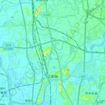
Name: 江高镇 topographic map, elevation, terrain.
Location: 江高镇, 白云区, 广州市, 广东省, 中国 (23.24537 113.14375 23.36400 113.26034)
Average elevation: 23 ft
Minimum elevation: -26 ft
Maximum elevation: 171 ft
Other topographic maps
Click on a map to view its topography, its elevation and its terrain.