Geolocate

白云山 topographic map

Interactive map

Click on the map to display elevation.

About this map

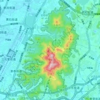
Name: 白云山 topographic map, elevation, terrain.

Location: 白云山, 白云区, 广州市, 广东省, 中国 (23.15709 113.26939 23.22215 113.31495)

Average elevation: 187 ft

Minimum elevation: -13 ft

Maximum elevation: 1,155 ft

Other topographic maps

Click on a map to view its topography, its elevation and its terrain.

张九龄纪念公园

中国 > 广东省 > 白云区

张九龄纪念公园, 石井街道, 白云区, 广州市, 广东省, 中国

Average elevation: 20 ft

江高镇

中国 > 广东省 > 白云区

江高镇, 白云区, 广州市, 广东省, 中国

Average elevation: 23 ft

西瓜岭

中国 > 广东省 > 白云区

西瓜岭, 钟落潭镇, 白云区, 广州市, 广东省, 中国

Average elevation: 112 ft

太和镇

中国 > 广东省 > 白云区

太和镇, 白云区, 广州市, 广东省, 510540, 中国

Average elevation: 335 ft

牛岭

中国 > 广东省 > 白云区

牛岭, 广州市, 白云区, 广东省, 510420, 中国

Average elevation: 187 ft