Geolocate

Mansfield topographic map

Click on the map to display elevation.

About this map

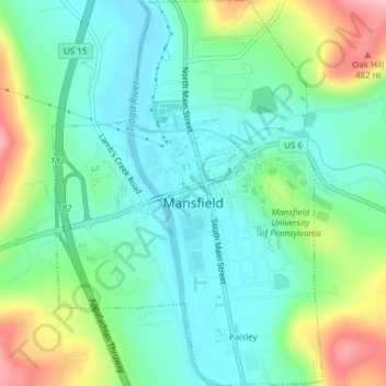
Name: Mansfield topographic map, elevation, terrain.

Location: Mansfield, Tioga County, Pennsylvania, 16933, United States (41.79229 -77.09309 41.82044 -77.06659)

Average elevation: 1,270 ft

Minimum elevation: 1,102 ft

Maximum elevation: 1,667 ft

Tioga County trails, hiking, mountain biking, running and outdoor activities

Other topographic maps

Click on a map to view its topography, its elevation and its terrain.

Williard

United States > Pennsylvania > Tioga County

Average elevation: 1,877 ft

Hartsfield

United States > Pennsylvania > Tioga County

Average elevation: 1,785 ft

Bear Run

United States > Pennsylvania > Tioga County > Landrus

Average elevation: 1,706 ft

Gaines

United States > Pennsylvania > Tioga County

Average elevation: 1,677 ft

Sebring

United States > Pennsylvania > Tioga County > Sebring

Average elevation: 1,909 ft

Gobblers Knob

United States > Pennsylvania > Tioga County

Average elevation: 1,755 ft

Gear up for your next adventure:

📡Handheld GPS Device - Reliable handheld GPS for outdoor navigation
👓Polarized Sunglasses - Outdoor sunglasses for glare reduction
🗺️NatGeo Topo Maps - High-quality waterproof printed topographic maps of US Parks
👖Convertible Hiking Pants - Versatile zip-off pants for changing altitudes and temperatures
🦶Hiking Gaiters - Keep debris and water out of your boots

As an Amazon Associate, this site earns from qualifying purchases at no extra cost to you.