Geolocate

Hartsfield topographic map

Click on the map to display elevation.

About this map

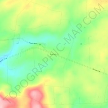
Name: Hartsfield topographic map, elevation, terrain.

Location: Hartsfield, Tioga County, Pennsylvania, United States (41.55591 -77.18497 41.59591 -77.14497)

Average elevation: 1,785 ft

Minimum elevation: 1,539 ft

Maximum elevation: 2,106 ft

Tioga County trails, hiking, mountain biking, running and outdoor activities

Other topographic maps

Click on a map to view its topography, its elevation and its terrain.

Westfield

United States > Pennsylvania > Tioga County

Average elevation: 1,578 ft

Bear Run

United States > Pennsylvania > Tioga County > Landrus

Average elevation: 1,706 ft

Elkland

United States > Pennsylvania > Tioga County > Elkland

Average elevation: 1,322 ft

Mansfield

United States > Pennsylvania > Tioga County

Average elevation: 1,270 ft

Gear up for your next adventure:

🗃️Trail First Aid Kit - Essential kit for outdoor injuries and emergencies
🏫Relief Map Kits - Hands-on tools for teaching landforms and elevation
📻Weather Alert Radios - Stay informed of storm risks while off-the-grid
🥩Freeze-Dried Meals - Nutritious and lightweight food for remote expeditions
🛰️Handheld GPS Units - Professional satellite navigators for precise backcountry mapping

As an Amazon Associate, this site earns from qualifying purchases at no extra cost to you.