
Make a donation
Gear up for your next adventure:
As an Amazon Associate, this site earns from qualifying purchases at no extra cost to you.
Gobblers Knob topographic map
Click on the map to display elevation.
Make a donation
Gear up for your next adventure:
As an Amazon Associate, this site earns from qualifying purchases at no extra cost to you.
About this map
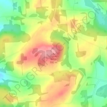
Name: Gobblers Knob topographic map, elevation, terrain.
Location: Gobblers Knob, Tioga County, Pennsylvania, United States (41.97919 -77.03474 41.97929 -77.03464)
Average elevation: 1,755 ft
Minimum elevation: 1,555 ft
Maximum elevation: 1,949 ft
Tioga County trails, hiking, mountain biking, running and outdoor activities
Make a donation
Gear up for your next adventure:
As an Amazon Associate, this site earns from qualifying purchases at no extra cost to you.
Other topographic maps
Click on a map to view its topography, its elevation and its terrain.
Pine Creek Gorge Natural Area
United States > Pennsylvania > Tioga County > Tiadaghton
Average elevation: 1,772 ft
Make a donation
Gear up for your next adventure:
As an Amazon Associate, this site earns from qualifying purchases at no extra cost to you.