Geolocate

Fafe topographic map

Interactive map

Click on the map to display elevation.

About this map

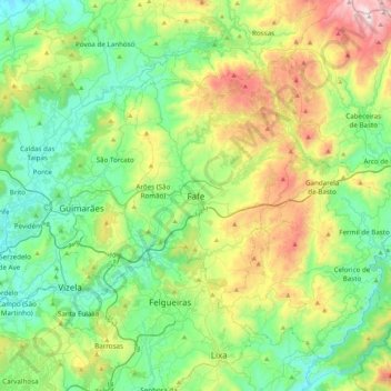
Name: Fafe topographic map, elevation, terrain.

Location: Fafe, Braga, 4820-142, Portugal (41.29141 -8.33085 41.61141 -8.01085)

Average elevation: 1,266 ft

Minimum elevation: 210 ft

Maximum elevation: 3,878 ft

Fafe situa-se num vale entre a Serra da Lameira, os Montes da Penha e outras montanhas. Numa vista aérea destacam-se três rios ladeados por arvoredo e que se espreguiçam pela periferia da cidade. São eles o Rio Ferro que tem a sua nascente em Ribeiros, o Rio do Bugio que inicia o seu percurso para os lados de S. Gens e o Rio Vizela que acolhe os outros dois e desagua no Rio Ave. O Rio Vizela nasce no Alto de Morgaír, na freguesia de Gontim, aos 894 m de altitude, sendo este o ponto mais alto do município. O município tem uma altitude média de 550 m.

Other topographic maps

Click on a map to view its topography, its elevation and its terrain.

Montim

Portugal > Braga > Fafe > Quinchães

Montim, Quinchães, Fafe, Braga, 4820-590, Portugal

Average elevation: 1,896 ft

Travassós

Portugal > Braga > Fafe

Travassós, Fafe, Braga, Portugal

Average elevation: 1,312 ft

Luilhas

Portugal > Braga > Fafe

Luilhas, Monte e Queimadela, Fafe, Braga, 4850-317, Portugal

Average elevation: 2,287 ft

Revelhe

Portugal > Braga > Fafe

Revelhe, Fafe, Braga, Portugal

Average elevation: 1,447 ft

Pedraído

Portugal > Braga > Fafe

Pedraído, Fafe, Braga, Portugal

Average elevation: 2,119 ft

Ardegão

Portugal > Braga > Fafe

Ardegão, Fafe, Braga, 4820-710, Portugal

Average elevation: 1,788 ft

Monte e Queimadela

Portugal > Braga > Fafe

Monte e Queimadela, Fafe, Braga, Portugal

Average elevation: 1,827 ft

Rio Ferro

Portugal > Braga > Fafe

Rio Ferro, Fafe, Braga, 4820-099, Portugal

Average elevation: 1,129 ft

Várzea Cova

Portugal > Braga > Fafe

Várzea Cova, Fafe, Braga, Portugal

Average elevation: 2,096 ft

Golães

Portugal > Braga > Fafe

Golães, Fafe, Braga, Portugal

Average elevation: 1,073 ft

Seidões

Portugal > Braga > Fafe

Seidões, Fafe, Braga, 4820-710, Portugal

Average elevation: 1,906 ft

Arnozela

Portugal > Braga > Fafe

Arnozela, Ardegão, Arnozela e Seidões, Fafe, Braga, 4820-710, Portugal

Average elevation: 1,886 ft

São Gens

Portugal > Braga > Fafe

São Gens, Fafe, Braga, 4820-570, Portugal

Average elevation: 1,591 ft

Queimadela

Portugal > Braga > Fafe

Queimadela, Fafe, Braga, 4820-511, Portugal

Average elevation: 1,913 ft

Fornelos

Portugal > Braga > Fafe

Fornelos, Fafe, Braga, Portugal

Average elevation: 1,033 ft

Requeixo

Portugal > Braga > Fafe > Travassós

Requeixo, Travassós, Fafe, Braga, 4820-466, Portugal

Average elevation: 1,302 ft

Paços

Portugal > Braga > Fafe

Paços, Fafe, Braga, Portugal

Average elevation: 1,286 ft

Freitas

Portugal > Braga > Fafe

Freitas, Freitas e Vila Cova, Fafe, Braga, Portugal

Average elevation: 1,168 ft

Bacelos

Portugal > Braga > Fafe

Bacelos, Cepães e Fareja, Fafe, Braga, 1177, Portugal

Average elevation: 883 ft

Agrela e Serafão

Portugal > Braga > Fafe

Agrela e Serafão, Fafe, Braga, Portugal

Average elevation: 1,066 ft

Arões (São Romão)

Portugal > Braga > Fafe

Arões (São Romão), Fafe, Braga, Portugal

Average elevation: 1,250 ft

Aboim

Portugal > Braga > Fafe > Aboim

Aboim, Fafe, Braga, 4850-317, Portugal

Average elevation: 2,257 ft

Aboim

Portugal > Braga > Fafe

Aboim, Fafe, Braga, Portugal

Average elevation: 2,238 ft

Regadas

Portugal > Braga > Fafe

Regadas, Fafe, Braga, Portugal

Average elevation: 1,565 ft

Lagoa

Portugal > Braga > Fafe

Lagoa, Aboim, Felgueiras, Gontim e Pedraído, Fafe, Braga, Portugal

Average elevation: 2,139 ft

Cepães

Portugal > Braga > Fafe

Cepães, Cepães e Fareja, Fafe, Braga, Portugal

Average elevation: 978 ft

Vila Pouca

Portugal > Braga > Fafe

Vila Pouca, Moreira do Rei e Várzea Cova, Fafe, Braga, 4820-840, Portugal

Average elevation: 2,106 ft