
Agrela e Serafão topographic map
Click on the map to display elevation.
About this map
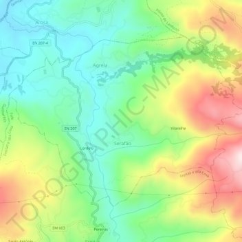
Name: Agrela e Serafão topographic map, elevation, terrain.
Location: Agrela e Serafão, Fafe, Braga, Portugal (41.51853 -8.22903 41.54783 -8.17320)
Average elevation: 1,066 ft
Minimum elevation: 430 ft
Maximum elevation: 2,116 ft
Other topographic maps
Click on a map to view its topography, its elevation and its terrain.
Fafe
Fafe situa-se num vale entre a Serra da Lameira, os Montes da Penha e outras montanhas. Numa vista aérea destacam-se três rios ladeados por arvoredo e que se espreguiçam pela periferia da cidade. São eles o Rio Ferro que tem a sua nascente em Ribeiros, o Rio do Bugio que inicia o seu percurso para os lados…
Average elevation: 1,266 ft