
Make a donation
Gear up for your next adventure:
As an Amazon Associate, this site earns from qualifying purchases at no extra cost to you.
Fornelos topographic map
Click on the map to display elevation.
Make a donation
Gear up for your next adventure:
As an Amazon Associate, this site earns from qualifying purchases at no extra cost to you.
About this map
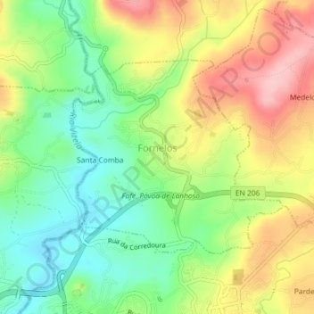
Name: Fornelos topographic map, elevation, terrain.
Location: Fornelos, Fafe, Braga, Portugal (41.45872 -8.18637 41.47539 -8.16210)
Average elevation: 1,033 ft
Minimum elevation: 801 ft
Maximum elevation: 1,332 ft
Make a donation
Gear up for your next adventure:
As an Amazon Associate, this site earns from qualifying purchases at no extra cost to you.
Other topographic maps
Click on a map to view its topography, its elevation and its terrain.
Fafe
Fafe situa-se num vale entre a Serra da Lameira, os Montes da Penha e outras montanhas. Numa vista aérea destacam-se três rios ladeados por arvoredo e que se espreguiçam pela periferia da cidade. São eles o Rio Ferro que tem a sua nascente em Ribeiros, o Rio do Bugio que inicia o seu percurso para os lados…
Average elevation: 1,266 ft
Make a donation
Gear up for your next adventure:
As an Amazon Associate, this site earns from qualifying purchases at no extra cost to you.
Make a donation
Gear up for your next adventure:
As an Amazon Associate, this site earns from qualifying purchases at no extra cost to you.
Make a donation
Gear up for your next adventure:
As an Amazon Associate, this site earns from qualifying purchases at no extra cost to you.
Make a donation
Gear up for your next adventure:
As an Amazon Associate, this site earns from qualifying purchases at no extra cost to you.