
Town of Carmel topographic map
Interactive map
Click on the map to display elevation.
About this map
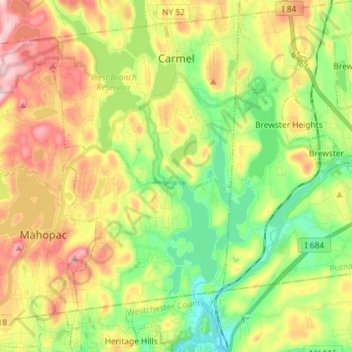
Name: Town of Carmel topographic map, elevation, terrain.
Location: Town of Carmel, Putnam County, New York, United States (41.34091 -73.79746 41.43976 -73.65316)
Average elevation: 548 ft
Minimum elevation: 197 ft
Maximum elevation: 1,024 ft
Other topographic maps
Click on a map to view its topography, its elevation and its terrain.
Graymoor
United States > New York > Putnam County
Graymoor, Town of Philipstown, Putnam County, New York, 10524, United States
Average elevation: 548 ft
Brewster Hill
United States > New York > Putnam County
Brewster Hill, Town of Southeast, Putnam County, New York, 10509, United States
Average elevation: 505 ft
Mahopac Falls
United States > New York > Putnam County > Mahopac
Mahopac Falls, Mahopac, Town of Carmel, Putnam County, New York, 10542, United States
Average elevation: 656 ft
Village of Nelsonville
United States > New York > Putnam County
Village of Nelsonville, Town of Philipstown, Putnam County, New York, United States
Average elevation: 456 ft
Village of Brewster
United States > New York > Putnam County
Village of Brewster, Town of Southeast, Putnam County, New York, United States
Average elevation: 479 ft
North Highlands
United States > New York > Putnam County
North Highlands, Town of Philipstown, Putnam County, New York, 10516, United States
Average elevation: 607 ft
Crafts
United States > New York > Putnam County > Carmel
Crafts, Carmel, Town of Carmel, Putnam County, New York, United States
Average elevation: 568 ft
South Highland
United States > New York > Putnam County
South Highland, Town of Philipstown, Putnam County, New York, 10524, United States
Average elevation: 584 ft
Canopus Lake
United States > New York > Putnam County
Canopus Lake, Town of Kent, Putnam County, New York, United States
Average elevation: 1,066 ft
Gilbert Corners
United States > New York > Putnam County > Town of Putnam Valley
Gilbert Corners, Town of Putnam Valley, Putnam County, New York, 10579, United States
Average elevation: 633 ft
Lake Peekskill
United States > New York > Putnam County > Town of Putnam Valley
Lake Peekskill, Town of Putnam Valley, Putnam County, New York, 10537, United States
Average elevation: 338 ft
Town of Putnam Valley
United States > New York > Putnam County
Town of Putnam Valley, Putnam County, New York, United States
Average elevation: 636 ft
Town of Southeast
United States > New York > Putnam County
Town of Southeast, Putnam County, New York, United States
Average elevation: 531 ft
Town of Philipstown
United States > New York > Putnam County
Town of Philipstown, Putnam County, New York, United States
Average elevation: 584 ft
Adams Corners
United States > New York > Putnam County > Town of Putnam Valley
Adams Corners, Town of Putnam Valley, Putnam County, New York, 10588, United States
Average elevation: 522 ft
Mahopac
United States > New York > Putnam County > Town of Carmel
Mahopac, Town of Carmel, Putnam County, New York, United States
Average elevation: 659 ft
Hortontown
United States > New York > Putnam County > Hortontown
Hortontown, Town of Kent, Putnam County, New York, United States
Average elevation: 833 ft
Crofts Corners
United States > New York > Putnam County > Town of Putnam Valley > Crofts Corners
Crofts Corners, Town of Putnam Valley, Putnam County, New York, 10579, United States
Average elevation: 463 ft
Kent Hills
United States > New York > Putnam County > Kent Hills
Kent Hills, Town of Kent, Putnam County, New York, 10512, United States
Average elevation: 820 ft
Mahopac Mines
United States > New York > Putnam County > Mahopac Mines
Mahopac Mines, Town of Carmel, Putnam County, New York, 10542, United States
Average elevation: 735 ft
Lake Carmel
United States > New York > Putnam County
Lake Carmel, Town of Kent, Putnam County, New York, 10512, United States
Average elevation: 725 ft
Garrison
United States > New York > Putnam County
Garrison, Town of Philipstown, Putnam County, New York, 10996, United States
Average elevation: 253 ft
Village of Cold Spring
United States > New York > Putnam County
Village of Cold Spring, Town of Philipstown, Putnam County, New York, United States
Average elevation: 141 ft
Carmel
United States > New York > Putnam County > Town of Carmel
Carmel, Town of Carmel, Putnam County, New York, United States
Average elevation: 531 ft