
Make a donation
Gear up for your next adventure:
As an Amazon Associate, this site earns from qualifying purchases at no extra cost to you.
Palma topographic map
Click on the map to display elevation.
Make a donation
Gear up for your next adventure:
As an Amazon Associate, this site earns from qualifying purchases at no extra cost to you.
Palma
Palma is a major city and seaport located in the southwest of Mallorca, a western Mediterranean island belonging to the Balearic Islands archipelago. The land area of the city is about 21.355 square kilometres (8.245 sq mi) with an altitude of 13 metres (43 feet) above sea level.
Make a donation
Gear up for your next adventure:
As an Amazon Associate, this site earns from qualifying purchases at no extra cost to you.
About this map
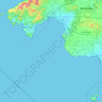
Name: Palma topographic map, elevation, terrain.
Location: Palma, Balearic Islands, Spain (39.12073 2.56385 39.65826 2.97986)
Average elevation: 148 ft
Minimum elevation: -3 ft
Maximum elevation: 3,133 ft
Make a donation
Gear up for your next adventure:
As an Amazon Associate, this site earns from qualifying purchases at no extra cost to you.
Other topographic maps
Click on a map to view its topography, its elevation and its terrain.
Paseo Marítimo de la Bahia de Sant Antoni de Portmany
Spain > Balearic Islands > Ibiza > Sant Antoni de Portmany
Average elevation: 36 ft
Serra de Tramuntana
Spain > Balearic Islands > Serra de Tramuntana
The climate in the Tramuntana Range is significantly wetter than the rest of the island, recording as much as 1507 mm (59.3 inches) of precipitation per year, in comparison with some other parts of the island where annual rainfall is less than 400mm (15 inch). It is also cooler due to the altitude, and a few…
Average elevation: 574 ft
Make a donation
Gear up for your next adventure:
As an Amazon Associate, this site earns from qualifying purchases at no extra cost to you.
Make a donation
Gear up for your next adventure:
As an Amazon Associate, this site earns from qualifying purchases at no extra cost to you.
Mirador d'es Colomer
Spain > Balearic Islands > Serra de Tramuntana > Port de Pollença
Average elevation: 259 ft
Make a donation
Gear up for your next adventure:
As an Amazon Associate, this site earns from qualifying purchases at no extra cost to you.
Make a donation
Gear up for your next adventure:
As an Amazon Associate, this site earns from qualifying purchases at no extra cost to you.
Make a donation
Gear up for your next adventure:
As an Amazon Associate, this site earns from qualifying purchases at no extra cost to you.
Urbanització Puig de Can Vinyets
Spain > Balearic Islands > Ibiza > Santa Eulària des Riu
Average elevation: 105 ft
Make a donation
Gear up for your next adventure:
As an Amazon Associate, this site earns from qualifying purchases at no extra cost to you.
Puig Major
Spain > Balearic Islands > Serra de Tramuntana > Escorca
Puig Major is the highest peak on the Spanish island of Majorca. With an elevation of 1,436 m (4,711 ft) above sea level. It is situated in the Serra de Tramuntana mountains. As the mountain is located in a military zone, the neighbouring peak Puig de Massanella (1,364 m) is considered the highest accessible…
Average elevation: 3,114 ft
Make a donation
Gear up for your next adventure:
As an Amazon Associate, this site earns from qualifying purchases at no extra cost to you.
Make a donation
Gear up for your next adventure:
As an Amazon Associate, this site earns from qualifying purchases at no extra cost to you.
Cova de ses Bruixes
Spain > Balearic Islands > Serra de Tramuntana > Pollença
Average elevation: 469 ft
Make a donation
Gear up for your next adventure:
As an Amazon Associate, this site earns from qualifying purchases at no extra cost to you.
Make a donation
Gear up for your next adventure:
As an Amazon Associate, this site earns from qualifying purchases at no extra cost to you.
Cala Grassio
Spain > Balearic Islands > Ibiza > Sant Antoni de Portmany > Can Germà > Cap Negret
Average elevation: 75 ft
Make a donation
Gear up for your next adventure:
As an Amazon Associate, this site earns from qualifying purchases at no extra cost to you.
Serra de Tramuntana
Spain > Balearic Islands > Serra de Tramuntana
The climate in the Tramuntana Range is significantly wetter than the rest of the island, recording as much as 1507 mm (59.3 inches) of precipitation per year, in comparison with some other parts of the island where annual rainfall is less than 400mm (15 inch). It is also cooler due to the altitude, and a few…
Average elevation: 574 ft
Make a donation
Gear up for your next adventure:
As an Amazon Associate, this site earns from qualifying purchases at no extra cost to you.
Make a donation
Gear up for your next adventure:
As an Amazon Associate, this site earns from qualifying purchases at no extra cost to you.
Make a donation
Gear up for your next adventure:
As an Amazon Associate, this site earns from qualifying purchases at no extra cost to you.
S' Illiot des Rencli
Spain > Balearic Islands > Ibiza > Sant Joan de Labritja
Average elevation: 184 ft
Make a donation
Gear up for your next adventure:
As an Amazon Associate, this site earns from qualifying purchases at no extra cost to you.
Make a donation
Gear up for your next adventure:
As an Amazon Associate, this site earns from qualifying purchases at no extra cost to you.
Torre del Ram
Spain > Balearic Islands > Menorca > Ciutadella > Cala en Blanes
Average elevation: 43 ft