
蟠龙镇 topographic map
Interactive map
Click on the map to display elevation.
About this map
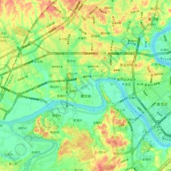
Name: 蟠龙镇 topographic map, elevation, terrain.
Location: 蟠龙镇, 赣州经济技术开发区, 章贡区, 赣州市, 江西省, 中国 (25.78231 114.80589 25.88070 114.91427)
Average elevation: 400 ft
Minimum elevation: 305 ft
Maximum elevation: 541 ft
Other topographic maps
Click on a map to view its topography, its elevation and its terrain.