
Make a donation
Gear up for your next adventure:
As an Amazon Associate, this site earns from qualifying purchases at no extra cost to you.
Mulliquindil topographic map
Click on the map to display elevation.
Make a donation
Gear up for your next adventure:
As an Amazon Associate, this site earns from qualifying purchases at no extra cost to you.
About this map
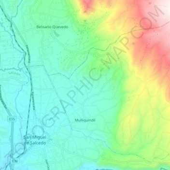
Name: Mulliquindil topographic map, elevation, terrain.
Location: Mulliquindil, Salcedo, Cotopaxi, Ecuador (-1.05494 -78.58395 -0.97677 -78.49737)
Average elevation: 9,436 ft
Minimum elevation: 8,530 ft
Maximum elevation: 11,860 ft
Make a donation
Gear up for your next adventure:
As an Amazon Associate, this site earns from qualifying purchases at no extra cost to you.
Other topographic maps
Click on a map to view its topography, its elevation and its terrain.
Make a donation
Gear up for your next adventure:
As an Amazon Associate, this site earns from qualifying purchases at no extra cost to you.
Laguna de Yambo
Ecuador > Cotopaxi > Salcedo > Patain > San Jose de Curiquingue
Average elevation: 8,740 ft
Make a donation
Gear up for your next adventure:
As an Amazon Associate, this site earns from qualifying purchases at no extra cost to you.