
水磨沟区 topographic map
Interactive map
Click on the map to display elevation.
About this map
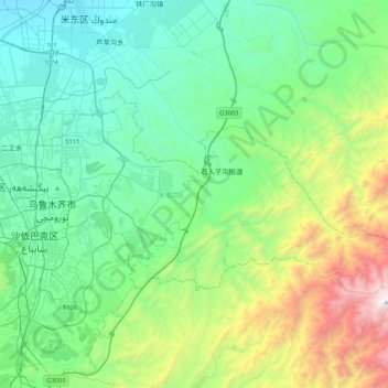
Name: 水磨沟区 topographic map, elevation, terrain.
Location: 水磨沟区, 乌鲁木齐市, 新疆维吾尔自治区, 830000, 中国 (43.75569 87.59550 43.91697 88.01435)
Average elevation: 3,757 ft
Minimum elevation: 1,844 ft
Maximum elevation: 10,171 ft
Other topographic maps
Click on a map to view its topography, its elevation and its terrain.