
柏杨河乡 topographic map
Interactive map
Click on the map to display elevation.
About this map
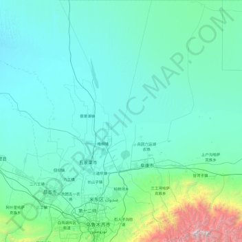
Name: 柏杨河乡 topographic map, elevation, terrain.
Location: 柏杨河乡, 米东区, 乌鲁木齐市, 新疆维吾尔自治区, 830000, 中国 (43.74689 87.33304 45.00066 88.14135)
Average elevation: 2,503 ft
Minimum elevation: 1,283 ft
Maximum elevation: 17,470 ft
Other topographic maps
Click on a map to view its topography, its elevation and its terrain.