
Make a donation
Gear up for your next adventure:
As an Amazon Associate, this site earns from qualifying purchases at no extra cost to you.
Neuengeseke topographic map
Click on the map to display elevation.
Make a donation
Gear up for your next adventure:
As an Amazon Associate, this site earns from qualifying purchases at no extra cost to you.
About this map
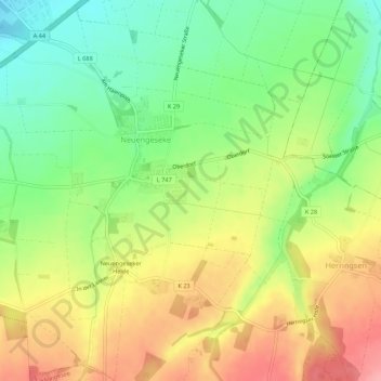
Name: Neuengeseke topographic map, elevation, terrain.
Average elevation: 581 ft
Minimum elevation: 413 ft
Maximum elevation: 771 ft
Make a donation
Gear up for your next adventure:
As an Amazon Associate, this site earns from qualifying purchases at no extra cost to you.
Other topographic maps
Click on a map to view its topography, its elevation and its terrain.
Oberhagen
Deutschland > Nordrhein-Westfalen > Kreis Soest > Warstein > Suttrop
Average elevation: 1,129 ft
Make a donation
Gear up for your next adventure:
As an Amazon Associate, this site earns from qualifying purchases at no extra cost to you.
Make a donation
Gear up for your next adventure:
As an Amazon Associate, this site earns from qualifying purchases at no extra cost to you.
Kutmecke
Deutschland > Nordrhein-Westfalen > Kreis Soest > Soest > Thöningsen
Average elevation: 282 ft
Make a donation
Gear up for your next adventure:
As an Amazon Associate, this site earns from qualifying purchases at no extra cost to you.
Talbereich des Sonnenborn-Borns- und Welschbach
Deutschland > Nordrhein-Westfalen > Kreis Soest > Waltringhausen
Average elevation: 564 ft
Make a donation
Gear up for your next adventure:
As an Amazon Associate, this site earns from qualifying purchases at no extra cost to you.
Make a donation
Gear up for your next adventure:
As an Amazon Associate, this site earns from qualifying purchases at no extra cost to you.
Wickede (Ruhr)
Deutschland > Nordrhein-Westfalen > Kreis Soest > Wickede (Ruhr) > Wickede (Ruhr)
Höchste Erhebung im Gemeindegebiet ist der Bellingser Berg mit einer Höhe von 238 m über NN. Der tiefste Punkt mit 128 m über NN befindet sich an der Ruhr an der Grenze zwischen Menden (Sauerland) und Fröndenberg/Ruhr.
Average elevation: 577 ft
Walburgerhofe
Deutschland > Nordrhein-Westfalen > Kreis Soest > Soest > Walburgerhofe
Average elevation: 308 ft
Make a donation
Gear up for your next adventure:
As an Amazon Associate, this site earns from qualifying purchases at no extra cost to you.
Belecke
Deutschland > Nordrhein-Westfalen > Kreis Soest > Warstein
Belecke ist seit 1975 ein Ortsteil der Stadt Warstein im Kreis Soest in Nordrhein-Westfalen (Deutschland). Zum 1. Oktober 2020 hatte er 5386 Einwohner. Der Ort liegt zwischen dem Haarstrang im Norden und dem Sauerland im Süden an der Möhne. Das Zentrum des Orts befindet sich auf einer Höhe von 255 Metern…
Average elevation: 955 ft
Make a donation
Gear up for your next adventure:
As an Amazon Associate, this site earns from qualifying purchases at no extra cost to you.
Bad Westernkotten
Deutschland > Nordrhein-Westfalen > Kreis Soest > Erwitte
Wirtschaftlich spielte im 19. Jahrhundert die Salzindustrie weiterhin die wichtigste Rolle und erreichte mit einer jährlichen Produktion von etwa 35.000 Zentnern um 1850 ihren Höhepunkt.
Average elevation: 308 ft
Ense
Deutschland > Nordrhein-Westfalen > Kreis Soest
Die Gemeinde Ense liegt am nördlichen Rande des Sauerlandes und am südwestlichen Rand der Soester Börde. Der Haarstrang verläuft etwa in der Mitte des Gemeindegebietes in West-Ost-Richtung. Dieser Höhenzug erreicht im Westen des Gemeindegebietes eine Höhe von ca. 230 m ü. NHN, im Osten etwa 260 m ü.…
Average elevation: 679 ft