Geolocate

San Saba topographic map

Click on the map to display elevation.

About this map

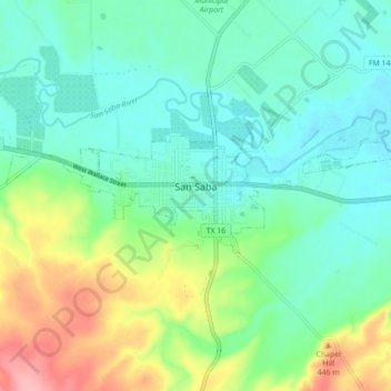
Name: San Saba topographic map, elevation, terrain.

Location: San Saba, San Saba County, Texas, 76877, United States (31.18216 -98.76544 31.20508 -98.67787)

Average elevation: 1,283 ft

Minimum elevation: 1,171 ft

Maximum elevation: 1,565 ft

San Saba County trails, hiking, mountain biking, running and outdoor activities

Other topographic maps

Click on a map to view its topography, its elevation and its terrain.

China Creek

United States > Texas > San Saba County > China Creek

Average elevation: 1,293 ft

Bend

United States > Texas > San Saba County

Average elevation: 1,148 ft

Harkeyville

United States > Texas > San Saba County

Average elevation: 1,234 ft

Skeeterville

United States > Texas > San Saba County

Average elevation: 1,388 ft

Chappel

United States > Texas > San Saba County

Average elevation: 1,355 ft

Gear up for your next adventure:

🪶Trail Camera - Capture wildlife on your hikes
🪓Survival Multi‑Tool - Versatile tool for camp and trail tasks
🧭Compass with Lanyard - Easy‑carry compass for navigation
🪶Fire Starter Kit - Reliable fire starter for survival and camping
🪶Thermal Camp Blanket - Extra warmth for cold nights

As an Amazon Associate, this site earns from qualifying purchases at no extra cost to you.