
Nehalem topographic map
Click on the map to display elevation.
Nehalem
Nehalem has an elevation of 11 feet. Lying so close to sea level, the area suffers intermittent floods. A 1996 storm caused particular damage, to local dairy farms. In November 2006, heavy rains caused flooding in Nehalem, resulting in $1 million in damage.
About this map
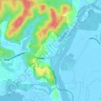
Name: Nehalem topographic map, elevation, terrain.
Location: Nehalem, Tillamook County, Oregon, 97131, United States (45.71068 -123.90044 45.72887 -123.88546)
Average elevation: 52 ft
Minimum elevation: -10 ft
Maximum elevation: 272 ft
Tillamook County trails, hiking, mountain biking, running and outdoor activities
Other topographic maps
Click on a map to view its topography, its elevation and its terrain.
Neahkahnie Mountain
United States > Oregon > Tillamook County
Neahkahnie Mountain is a mountain, or headland, on the Oregon Coast, north of Manzanita in Oswald West State Park overlooking U.S. Route 101, that has a pass elevation of approximately 620 feet (190 m), which is the third highest point of the highway in Oregon. The peak is part of the Northern Oregon Coast…
Average elevation: 538 ft
Seaview City Park
United States > Oregon > Tillamook County > Rockaway Beach
Average elevation: 105 ft