Geolocate

Angier topographic map

Click on the map to display elevation.

About this map

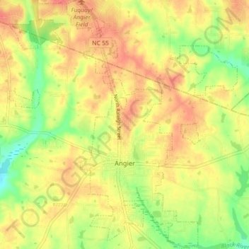
Name: Angier topographic map, elevation, terrain.

Location: Angier, Harnett County, North Carolina, United States (35.48716 -78.77254 35.54506 -78.70701)

Average elevation: 299 ft

Minimum elevation: 194 ft

Maximum elevation: 371 ft

Harnett County trails, hiking, mountain biking, running and outdoor activities

Other topographic maps

Click on a map to view its topography, its elevation and its terrain.

Pineview

United States > North Carolina > Harnett County

Average elevation: 299 ft

Twin Lakes

United States > North Carolina > Harnett County

Average elevation: 243 ft

Bunnlevel

United States > North Carolina > Harnett County

Average elevation: 144 ft

Harnett

United States > North Carolina > Harnett County > Harnett

Average elevation: 151 ft

Gear up for your next adventure:

🔦Powerful Headlamps - Ultra-bright hands-free lighting for night navigation
🎒Trekking Poles - Sturdy poles for balance and stability on rough terrain
🗺️Topographic Maps - Detailed topo maps for hiking, exploring and outdoor navigation
📦Dry Bags Set - Waterproof storage for electronics and clothes
🌐World Map Poster - Decorative world maps with topographic info

As an Amazon Associate, this site earns from qualifying purchases at no extra cost to you.