
Onondaga County topographic map
Interactive map
Click on the map to display elevation.
About this map
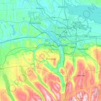
Name: Onondaga County topographic map, elevation, terrain.
Location: Onondaga County, New York, United States (42.77129 -76.49957 43.27159 -75.89582)
Average elevation: 764 ft
Minimum elevation: 341 ft
Maximum elevation: 2,034 ft
According to the U.S. Census Bureau, the county has an area of 806 square miles (2,090 km2), of which 778 square miles (2,020 km2) is land and 27 square miles (70 km2) (3.4%) is water. The geographic dimensions of the county are illustrated as approximately 35 miles (56 km) in length and 30 miles (48 km) in width, and comprising 25 miles (40 km) of the New York State Barge Canal System, in combination with a number of lakes, streams and rivers. Onondaga County is in the central portion of New York State, west of Albany and Utica, east of Rochester and northeast of Ithaca. Onondaga Lake is bordered by many of the larger communities in the county. The highest point in Onondaga County is at 2057 feet, along Morgan Hill located just east of Morgan Hill State Forest on private property. The second highest point in Onondaga County is at 2019 feet elevation and on the summit of Fellows Hill which is located in Morgan Hill State Forest near Fabius and Apulia south of state route 80.
Other topographic maps
Click on a map to view its topography, its elevation and its terrain.
Manhattan
United States > New York > New York County > New York
Manhattan, New York County, New York, United States
Average elevation: 52 ft
City of Ithaca
United States > New York > Tompkins County
City of Ithaca, Tompkins County, New York, United States
Average elevation: 640 ft
City of Binghamton
United States > New York > Broome County
City of Binghamton, Dickinson, Broome County, New York, 13905, United States
Average elevation: 1,053 ft
Montauk
United States > New York > Suffolk County > Town of East Hampton
Montauk, Town of East Hampton, Suffolk County, New York, 11954, United States
Average elevation: 7 ft
City of Plattsburgh
United States > New York > Clinton County
City of Plattsburgh, Clinton County, New York, United States
Average elevation: 164 ft
Dutchess County
Dutchess County, New York, United States
Average elevation: 587 ft
Saratoga Springs
United States > New York > Saratoga County > Saratoga Springs
Saratoga Springs, City of Saratoga Springs, Saratoga County, New York, 12866, United States
Average elevation: 528 ft
Village of East Rockaway
United States > New York > Nassau County
Village of East Rockaway, Town of Hempstead, Nassau County, New York, 11518, United States
Average elevation: 20 ft
Upper West Side
United States > New York > New York
Upper West Side, Manhattan Community Board 7, Manhattan, New York County, New York, United States
Average elevation: 75 ft
Brooklyn
United States > New York > New York
Brooklyn, Kings County, New York, United States
Average elevation: 30 ft
Buffalo
United States > New York > Erie County
Buffalo, Erie County, New York, United States
Average elevation: 607 ft
City of Syracuse
United States > New York > Onondaga County
City of Syracuse, Onondaga County, New York, United States
Average elevation: 564 ft
Monroe County
Monroe County, New York, United States
Average elevation: 400 ft
City of Schenectady
United States > New York > Schenectady County
City of Schenectady, Schenectady County, New York, 12345, United States
Average elevation: 328 ft
Michael Ciaiola Conservation Area
United States > New York > Putnam County > Town of Patterson > Putnam Lake
Michael Ciaiola Conservation Area, Putnam Lake, Town of Patterson, Putnam County, New York, United States
Average elevation: 965 ft
Town of Catskill
United States > New York > Greene County
Town of Catskill, Greene County, New York, United States
Average elevation: 194 ft
Manhattan Island
United States > New York > New York
Manhattan Island, New York, United States
Average elevation: 56 ft
Adirondack Park
Adirondack Park, New York, United States
Average elevation: 1,217 ft
Staten Island
United States > New York > New York
Staten Island, Richmond County, New York, United States
Average elevation: 30 ft
Tompkins County
Tompkins County, New York, United States
Average elevation: 1,237 ft
Saratoga County
Saratoga County, New York, United States
Average elevation: 715 ft
Westchester County
Westchester County, New York, United States
Average elevation: 312 ft
Erie Canal
United States > New York > Erie County > City of Tonawanda
Erie Canal, City of Tonawanda, Erie County, New York, United States
Average elevation: 581 ft
East Hampton
United States > New York > Suffolk County > East Hampton > Village of East Hampton
East Hampton, Village of East Hampton, Suffolk County, New York, 11937, United States
Average elevation: 39 ft
City of Rye
United States > New York > Westchester County
City of Rye, Westchester County, New York, United States
Average elevation: 30 ft
Lake George
United States > New York > Warren County > Town of Bolton
Lake George, Town of Bolton, Warren County, New York, United States
Average elevation: 810 ft
Cortland County
Cortland County, New York, United States
Average elevation: 1,486 ft
Women's Rights National Historical Park
United States > New York > Seneca County > Seneca Falls
Women's Rights National Historical Park, Seneca Falls, Town of Seneca Falls, Seneca County, New York, United States
Average elevation: 463 ft
Town of Clifton Park
United States > New York > Saratoga County
Town of Clifton Park, Saratoga County, New York, United States
Average elevation: 279 ft
Putnam County
Putnam County, New York, United States
Average elevation: 554 ft
Hamlet of Copake
United States > New York > Columbia County
Hamlet of Copake, Town of Copake, Columbia County, New York, United States
Average elevation: 577 ft
Town of Bath
United States > New York > Steuben County
Town of Bath, Steuben County, New York, United States
Average elevation: 1,476 ft
City of White Plains
United States > New York > Westchester County
City of White Plains, Westchester County, New York, United States
Average elevation: 272 ft
City of Yonkers
United States > New York > Westchester County
City of Yonkers, Westchester County, New York, United States
Average elevation: 190 ft
Town of Huntington
United States > New York > Suffolk County
Town of Huntington, Suffolk County, New York, United States
Average elevation: 98 ft
The Bronx
United States > New York > New York
The Bronx, New York, United States
Average elevation: 75 ft
Orange County
Orange County, New York, United States
Average elevation: 636 ft
Central Park
United States > New York > New York County > New York
Central Park, New York County, New York, United States
Average elevation: 85 ft
Rensselaer County
Rensselaer County, New York, United States
Average elevation: 784 ft
Finger Lakes National Forest
United States > New York > Schuyler County > Town of Hector
Finger Lakes National Forest, Town of Hector, Schuyler County, New York, 14818, United States
Average elevation: 1,168 ft
Brewster Heights
United States > New York > Putnam County
Brewster Heights, Town of Southeast, Putnam County, New York, 10508, United States
Average elevation: 479 ft
Oneida County
Oneida County, New York, United States
Average elevation: 1,086 ft
Lamberton
United States > New York > Chautauqua County
Lamberton, Town of Pomfret, Chautauqua County, New York, 14166, United States
Average elevation: 751 ft
Ulster County
Ulster County, New York, United States
Average elevation: 1,125 ft
East Meadow
United States > New York > Nassau County
East Meadow, Town of Hempstead, Nassau County, New York, 11554, United States
Average elevation: 85 ft