
Town of Clifton Park topographic map
Interactive map
Click on the map to display elevation.
Town of Clifton Park
Clifton Park features a predominantly gentle terrain characterized by rolling hills and a mixture of forested areas, open fields, and suburban developments. The elevation in this area varies, generally ranging from around 300 to 500 feet above sea level, contributing to a picturesque landscape that integrates natural beauty with residential neighborhoods. The town is interspersed with parks and recreational spaces, including a network of approximately 15 miles of trails that enhance its accessibility to nature. Additionally, its topography supports a blend of rural and urban elements, preserving historical sites while accommodating modern growth and development.
About this map
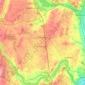
Name: Town of Clifton Park topographic map, elevation, terrain.
Average elevation: 279 ft
Minimum elevation: 3 ft
Maximum elevation: 489 ft
Saratoga County trails, hiking, mountain biking, running and outdoor activities
Other topographic maps
Click on a map to view its topography, its elevation and its terrain.
Saratoga Springs
United States > New York > Saratoga County > Saratoga Springs
Average elevation: 528 ft
Vischer Ferry
United States > New York > Saratoga County > Town of Clifton Park
Average elevation: 243 ft
Halfmoon
United States > New York > Saratoga County > Halfmoon
Halfmoon is a town in Saratoga County, New York, United States. The population was 21,535 at the 2010 census. The town is apparently named for the shape of the lower elevation land north of the junction of the Hudson and Mohawk Rivers. It is also said to be named for Henry Hudson's ship.
Average elevation: 276 ft
Elnora
United States > New York > Saratoga County > Town of Clifton Park > Elnora
Average elevation: 322 ft