Geolocate

Karachuonyo topographic map

Click on the map to display elevation.

About this map

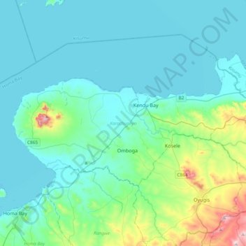
Name: Karachuonyo topographic map, elevation, terrain.

Location: Karachuonyo, Homa Bay County, Nyanza, Kenya (-0.48870 34.44690 -0.29852 34.81934)

Average elevation: 4,006 ft

Minimum elevation: 3,701 ft

Maximum elevation: 5,833 ft

Other topographic maps

Click on a map to view its topography, its elevation and its terrain.

Kobala

Kenya > Homa Bay County

Average elevation: 3,868 ft

Kendu Bay

Kenya > Homa Bay County

Average elevation: 3,832 ft

Gear up for your next adventure:

🔋Solar Power Banks - Keep your GPS and phone charged in remote wilderness areas
🥘Titanium Cookware - Durable, featherlight pots and pans for backpacking
🥤Water Filter Bottle - All‑in‑one filter bottle for safe hydration
🪶Paracord Bracelet - Survival bracelet with built‑in tools
👓Polarized Sunglasses - Outdoor sunglasses for glare reduction

As an Amazon Associate, this site earns from qualifying purchases at no extra cost to you.