Geolocate

Wommelgem topographic map

Click on the map to display elevation.

About this map
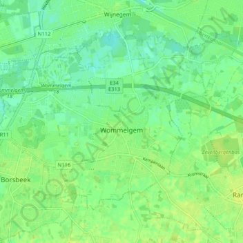
Name: Wommelgem topographic map, elevation, terrain.

Location: Wommelgem, Antwerp, Flanders, 2160, Belgium (51.18662 4.48230 51.22300 4.56228)

Average elevation: 30 ft

Minimum elevation: 3 ft

Maximum elevation: 46 ft

Other topographic maps

Click on a map to view its topography, its elevation and its terrain.
Antwerp

Belgium > Antwerp > Antwerp > Antwerp

Average elevation: 16 ft

Lillo-Fort

Belgium > Antwerp > Antwerp > Antwerp

Average elevation: 10 ft

Antwerp

Belgium > Antwerp > Antwerp > Antwerp

Average elevation: 30 ft

Interescaut

Belgium > Antwerp > Antwerp > Schelle

Average elevation: 16 ft

Essenhout

Belgium > Antwerp > Antwerp > Kapellen

Average elevation: 20 ft

Bosstraat

Belgium > Antwerp > Antwerp > Boom

Average elevation: 39 ft

Deuzeld

Belgium > Antwerp > Antwerp > Schoten

Average elevation: 20 ft

Donk

Belgium > Antwerp > Antwerp > Antwerp > Ekeren

Average elevation: 20 ft

Gear up for your next adventure:

🗺️NatGeo Topo Maps - High-quality waterproof printed topographic maps of US Parks
🛡️Bear Spray Outdoor - Protection in bear country hikes
🔌Solar Panel Charger - Charge gear sustainably outdoors
📱Heavy-Duty Phone Cases - Drop-proof and waterproof protection for outdoor navigation
🌎3D Topographic Globes - Raised relief globes for a tactile understanding of geography

As an Amazon Associate, this site earns from qualifying purchases at no extra cost to you.